Filter: Categories of Wisconsin Historical Images
Filter: Subject of Dams
Filter: Year of 1900-1999
Filter: Year of 1950-1959
Filter: Categories of Wisconsin Historical Images
Filter: Subject of Dams
Filter: Year of 1900-1999
Filter: Year of 1950-1959
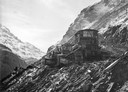
| Date: | 1953 |
|---|---|
| Description: | International TD-24 and TD-18 TracTracTors (crawler tractors) at work on the site of the Mauvoisin Dam in Switzerland's Mont Blanc region. The dam, begun i... |
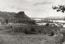
| Date: | 1953 |
|---|---|
| Description: | View across fields towards the Genoa Dam on the Mississippi River. Tree-covered hills are on the left. |

| Date: | 04 1959 |
|---|---|
| Description: | The Mississippi River Logging Company's dam built in Soft Maple Creek in 1877. |

| Date: | 04 1959 |
|---|---|
| Description: | The Mississippi River Logging Company's dam built in Soft Maple Creek in 1877. |
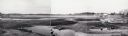
| Date: | 1958 |
|---|---|
| Description: | Plover River Pond; the dam was out and the pond is dry, permitting an unusual view of the immediate area. Highway 51 and a bridge can be seen in the distan... |
| Date: | 1950 |
|---|---|
| Description: | View of the Wisconsin River dam. |
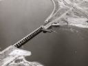
| Date: | 1955 |
|---|---|
| Description: | Aerial view of Castle Rock Dam on the Wisconsin River. |

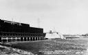
| Date: | 1950 |
|---|---|
| Description: | Aerial view of the Highway 21 bridge and Petenwell Dam on the Wisconsin River. |
| Date: | 1958 |
|---|---|
| Description: | International Payhaulers haul dirt up a steep canyon wall ascent while working on the Glen Canyon Dam on the Colorado River. |
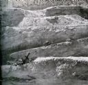
| Date: | 1958 |
|---|---|
| Description: | A riverside crew is alerted of a payhauler's descent during construction on the Glen Canyon Dam on the Colorado River. |

| Date: | 1959 |
|---|---|
| Description: | Color photo of an International truck driving beneath a bridge spanning a dam on the Colorado River. |

| Date: | 02 1956 |
|---|---|
| Description: | This 1956 map of Waukesha County, Wisconsin, shows the township and range grid, towns, sections, cities and villages, roads, railroads, dams, airports, par... |

| Date: | 01 08 1959 |
|---|---|
| Description: | Work on the new Tenney Park lock and dam is progressing on schedule. A temporary spillway (not shown) has been built to divert the Yahara River from the co... |

| Date: | 07 18 1955 |
|---|---|
| Description: | Five teen boys stand ankle deep in Black Earth Creek (west of Cross Plains) while working together to build a conversion dam in the creek bed. The boys are... |

| Date: | 07 18 1955 |
|---|---|
| Description: | Two teen boys and an adult stand in ankle deep Black Earth Creek (west of Cross Plains) while working together to build a "V" shaped conversion dam, pointi... |
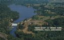
| Date: | 1950 |
|---|---|
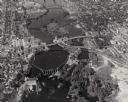
| Description: | Color postcard aerial view. Caption reads: "'Glen Lock' at Irvine Park, Chippewa Falls, Wisconsin." Caption on back reads: "This view from Irvine Park show... |

| Date: | 11 15 1957 |
|---|---|
| Description: | This map shows single family residence district, business district, and manufacturing district, as well as block and lot numbers, Hustis Homestead, gravel ... |

| Date: | 1951 |
|---|---|
| Description: | This map shows land use, dwellings, resorts, camps, marshes, springs, dams, lake bottom composition, and access. The map includes a fish species table, geo... |
If you didn't find the material you searched for, our Library Reference Staff can help.
Call our reference desk at 608-264-6535 or email us at: