 Filter: Categories of Wisconsin Historical Images
Filter: Subject of Dams
Filter: Subject of botany
Filter: Subject of landforms
Filter: Categories of Wisconsin Historical Images
Filter: Subject of Dams
Filter: Subject of botany
Filter: Subject of landforms

| Date: | 1893 |
|---|---|
| Description: | Bird's-eye map of Jefferson, looking north. Crayfish River at left and center, Rock River from upper center to bottom center, joins at left of center; thir... |

| Date: | 12 21 1882 |
|---|---|
| Description: | Bird's-eye map of Kaukauna, from the Appleton Post Annual Review. |
| Date: | 1856 |
|---|---|
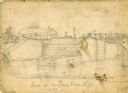
| Description: | An original illustration of the lock at Rexford Flats. |

| Date: | 1895 |
|---|---|
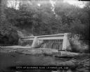
| Description: | View of a mill, sluice and dam on Waumandee Creek. The mill was built by John Oschner in 1863. Two products produced by the mill were White Rose Flour and ... |
| Date: | 1895 |
|---|---|
| Description: | Munger's Mill and dam, with men standing on and around the dam. |
| Date: | 05 19 1895 |
|---|---|
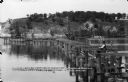
| Description: | Elevated view of the dam on the Fox River at Buffalo Lake. Houses and other buildings are visible in the background. |
| Date: | 06 19 1911 |
|---|---|
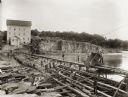
| Description: | Looking west over the Wisconsin River at the unfinished narrow gauge railroad trestle built for construction of the dam. Two pile drivers are seen in the a... |
| Date: | 06 13 1913 |
|---|---|
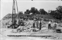
| Description: | Workmen and machinery at the quarry on Blackhawk Bluff. The gravel was used in construction of the power dam. |
| Date: | 06 13 1913 |
|---|---|
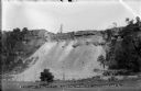
| Description: | A view, from the west, of the quarry on Blackhawk Bluff. Gravel from the quarry was used in concrete for the construction of the power plant and dam. |
| Date: | 05 06 1894 |
|---|---|
| Description: | Monongahela River view of a dam at Lock #2. |
| Date: | |
|---|---|
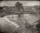
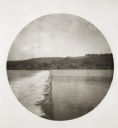
| Description: | View from shoreline of dam on Kickapoo River. There is a steep hill on the left, and both sides of riverbank are covered with trees. |
| Date: | 1936 |
|---|---|
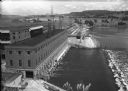
| Description: | Elevated view of the power dam on the Wisconsin River at Prairie du Sac. |
| Date: | 1910 |
|---|---|
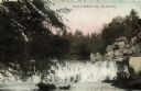
| Description: | View across water towards the dam or waterfall across Mirror Lake. There are tree branches in the foreground on the left, and rock formations above the fal... |
| Date: | 1910 |
|---|---|
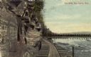
| Description: | Colored photographic postcard view of the dells below the dam on the Chippewa river. There is a boardwalk at the base of the cliff leading to the dam. Capt... |
| Date: | 1936 |
|---|---|
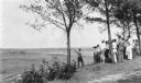
| Description: | A crowd has gathered on a hilltop overlooking a large flat expanse which has been cleared of trees. A man is standing slightly downhill from the group and ... |
If you didn't find the material you searched for, our Library Reference Staff can help.
Call our reference desk at 608-264-6535 or email us at: