Filter: Categories of Wisconsin Historical Images
Filter: Subject of Croplands
Filter: Subject of intellectual life
Filter: Categories of Wisconsin Historical Images
Filter: Subject of Croplands
Filter: Subject of intellectual life

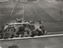
| Date: | 1956 |
|---|---|
| Description: | Aerial view of upper campus of the University of Wisconsin-Madison with Lake Mendota. |

| Date: | 1930 |
|---|---|
| Description: | Two airplanes refueling in flight over Morey Airport. The airport and farmland can be seen in the distance. |

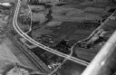
| Date: | 1965 |
|---|---|
| Description: | Elevated view of roads, railroad tracks, building, farm fields, and a body of water. |

| Date: | 1931 |
|---|---|
| Description: | A company photographer sets up his camera on top of a car to take a photograph in a field. |
| Date: | 1946 |
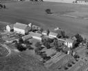
|---|---|
| Description: | Aerial view of farm which is part of the University of Wisconsin-Madison. In the foreground is a tree-lined road. The farm has several buildings, including... |

| Date: | 1930 |
|---|---|
| Description: | Aerial view, looking northeast, across Mud Lake with North Bay in the background, showing cultivated fields and wooded land. |

| Date: | 1930 |
|---|---|
| Description: | Aerial view of the northern tip of the Door Peninsula, looking north. Europe Lake is in the center, with Europe Bay to the right. Plum Island and Washingto... |
| Date: | 1935 |
|---|---|
| Description: | Page 2 of textual description of Brundage family and their resettlement from poor farmland to land better suited to agriculture. |
| Date: | 1958 |
|---|---|
| Description: | Aerial view of Kapec Orchards on Verona Road between McKee and Nesbitt Roads. |

| Date: | 1760 |
|---|---|
| Description: | Map showing the towns, mountains, valleys, corn fields, and rivers of a portion of the Cherokee Nation. A few annotations on the map explain the land and r... |
If you didn't find the material you searched for, our Library Reference Staff can help.
Call our reference desk at 608-264-6535 or email us at: