 Filter: Categories of Wisconsin Historical Images
Filter: Subject of Corn
Filter: Subject of valleys
Filter: Categories of Wisconsin Historical Images
Filter: Subject of Corn
Filter: Subject of valleys
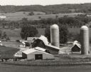
| Date: | 06 1976 |
|---|---|
| Description: | Caption on back of photograph: "Tom Nee farm, 3 miles SE of Richland Center. Looking west over Pine River Valley. Early summer, 1976. TION; RIE; S 1/2 NW 1... |

| Date: | 1900 |
|---|---|
| Description: | View across partially harvested cornfield of a man on a horse-drawn corn binder. Behind the horses is a tower structure, perhaps for a windmill. The cornfi... |

| Date: | 1760 |
|---|---|
| Description: | Map showing the towns, mountains, valleys, corn fields, and rivers of a portion of the Cherokee Nation. A few annotations on the map explain the land and r... |
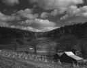
| Date: | 1950 |
|---|---|
| Description: | View down hill towards a farm in a valley, with harvested corn in corn shocks in the field. Tree-lined hills are in the background. Text on reverse of imag... |
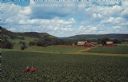
| Date: | 1950 |
|---|---|
| Description: | Text on front reads: "Greetings from Spring Green, Wis." On the reverse it reads: "Lush Farm Land." Elevated view of a farmer on a tractor in a large corn ... |
If you didn't find the material you searched for, our Library Reference Staff can help.
Call our reference desk at 608-264-6535 or email us at: