 Filter: Categories of Wisconsin Historical Images
Filter: Subject of Command of troops
Filter: Reproduction Rights of For Sale
Filter: Subject of land use
Filter: Categories of Wisconsin Historical Images
Filter: Subject of Command of troops
Filter: Reproduction Rights of For Sale
Filter: Subject of land use

| Date: | 1760 |
|---|---|
| Description: | Map showing the towns, mountains, valleys, corn fields, and rivers of a portion of the Cherokee Nation. A few annotations on the map explain the land and r... |

| Date: | |
|---|---|
| Description: | His Excellency Count Alexander von Krobatin served as the Imperial Austro-Hungarian War Minister from 1912 to 1917. |
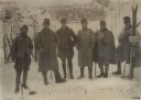
| Date: | |
|---|---|
| Description: | The commander of a fort on the Tirolian front at an elevation of 3500 meters surrounded by his officers. 1. Major Hyza; 2. Lieutenant Joseph Aldon; 3. Lieu... |
If you didn't find the material you searched for, our Library Reference Staff can help.
Call our reference desk at 608-264-6535 or email us at: