Filter: Categories of Wisconsin Historical Images
Filter: Subject of Clothing and dress
Filter: Subject of weapons
Filter: Subject of rivers
Filter: Categories of Wisconsin Historical Images
Filter: Subject of Clothing and dress
Filter: Subject of weapons
Filter: Subject of rivers
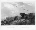
| Date: | 1845 |
|---|---|
| Description: | Illustration of Chippewa and Sioux Indians battling each other at the Brule River. Wood engraving from Armstrong, "Early Life Among The Indians." |

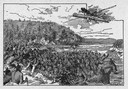
| Date: | 1821 |
|---|---|
| Description: | Indians of the North Red River area, probably in the vicinity of old Fort Douglas, now Winnipeg, Canada, spearing beaver. |
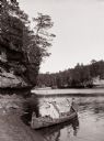
| Date: | |
|---|---|
| Description: | Two men dressed as "Indians" are sitting in a canoe at the edge of the beach. One is posing holding a bow and arrow, the other is holding a paddle. |
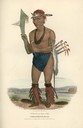
| Date: | 1835 |
|---|---|
| Description: | Cut-taa-tas-tia, a celebrated Chief of the Fox Tribe. Hand-colored lithograph from the Aboriginal Portfolio, was drawn at the Treaty of Prairie du Chien (1... |

| Date: | 1937 |
|---|---|
| Description: | Label submitted to the state of Wisconsin for trademark registration. "Pioneer Beer, G. Weber Brewing Co." Under this in the center is a leaf with the lett... |
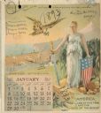
| Date: | 1893 |
|---|---|
| Description: | Calendar front, with the month of January, 1893. At the top it reads: "1893 calendar presented to the farmers of the world with the compliments of Aultman,... |

| Date: | 1910 |
|---|---|
| Description: | Three people on a raft, all wearing blue shirts. Two of the people are standing and holding shields and spears, while the third person is sitting in the mi... |

| Date: | 1790 |
|---|---|
| Description: | An updated and corrected version of Robert de Vaugondy's 1750 map "Amérique Septentrionale: Dressée sur les Relations les Plus Modernes des Voyageurs et Na... |

| Date: | 1667 |
|---|---|
| Description: | Map of Virginia depicting the discoveries detailed by John Smith in his exploration of the region. It shows Jamestown, Native American tribes and villages,... |

| Date: | 1609 |
|---|---|
| Description: | Illustration of an elevated view of a battle between Iroquois tribe and French on the banks of river. The Iroquois are unclothed and armed with bows and ar... |
If you didn't find the material you searched for, our Library Reference Staff can help.
Call our reference desk at 608-264-6535 or email us at: