Filter: Categories of Wisconsin Historical Images
Filter: Subject of Clothing and dress
Filter: Subject of transportation
Filter: Subject of marshes
Filter: Categories of Wisconsin Historical Images
Filter: Subject of Clothing and dress
Filter: Subject of transportation
Filter: Subject of marshes
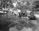
| Date: | 1916 |
|---|---|
| Description: | Man pulling wagons through water with an experimental 8-16(?) tractor with six wheels. |
| Date: | |
|---|---|
| Description: | Elevated view of a group of children, infants, and adults sitting in rowboats in the water at Manasquan Beach. In the background are rows of dwellings, and... |
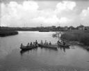
| Date: | 1895 |
|---|---|
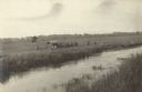
| Description: | Group of men, with women passengers, poling canoes through a marshy stretch of water on the Brule River-St. Croix River portage between Lake Superior and t... |

| Date: | |
|---|---|
| Description: | Cranberry harvesters at work. Mural painting in the U.S. Post Office at Berlin, Wis. |
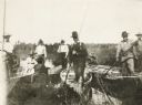
| Date: | 1910 |
|---|---|
| Description: | View across water towards a group of seven men posing on a dock in front of a small hunting shack in the middle of a marsh. Ducks hang on stringers attache... |
| Date: | 1918 |
|---|---|
| Description: | Elevated view across stream in marshy area towards a group of people gathered around an aircraft wreck. |

| Date: | |
|---|---|
| Description: | View across water of a Menominee man standing in a canoe in a marsh. He is holding a paddle in his hand. Behind him on the left is another canoe with three... |

| Date: | |
|---|---|
| Description: | Vel Phillips, wearing a coat and a hat, stands on a gravel road with her husband, W. Dale Phillips, who is wearing a coat and eyeglasses. The marsh is in t... |
| Date: | |
|---|---|
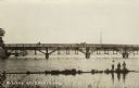
| Description: | View from shore towards a bridge crossing a river. Three boys are standing in the marshy foreground, and one of them has a fishing pole. A horse and buggy ... |

| Date: | 1770 |
|---|---|
| Description: | Map of North America from the Great Lakes to the northern portion of South America. It shows cities, Native American land, mountains, swamps, lakes, rivers... |

| Date: | 1755 |
|---|---|
| Description: | Map of Virginia and parts of Maryland, North Carolina, and New Jersey. It shows borders, boundary lines, some Native American land, counties, cities, towns... |
| Date: | |
|---|---|
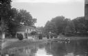
| Description: | View across water towards a section of Sandy Beach Resort. There are people on the lawn on the left next to buildings. Two women are talking on a porch in ... |
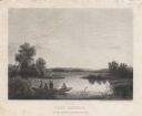
| Date: | 1858 |
|---|---|
| Description: | Engraved print of four men and a dog in a boat on Lake Winnebago. Two of the men are in the center of the boat holding hunting rifles, while one man is sta... |
| Date: | 09 02 1966 |
|---|---|
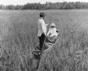
| Description: | The caption on the reverse of this print explains: "Indians harvesting wild rice. Man poles rice boat while wife uses cedar ricing sticks and strips grain ... |

| Date: | 1950 |
|---|---|
| Description: | View from shoreline towards two men in a canoe near Birch Point on Little Elkhart Lake. The day is overcast. Around the point is another man in a boat, and... |

| Date: | 1905 |
|---|---|
| Description: | View from shoreline looking towards two women wearing large hats who are sitting in a carriage drawn by a matched team of horses. The carriage has stopped ... |
If you didn't find the material you searched for, our Library Reference Staff can help.
Call our reference desk at 608-264-6535 or email us at: