 Filter: Categories of Wisconsin Historical Images
Filter: Subject of Clothing and dress
Filter: Subject of transportation
Filter: Subject of exploration
Filter: Categories of Wisconsin Historical Images
Filter: Subject of Clothing and dress
Filter: Subject of transportation
Filter: Subject of exploration
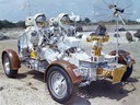
| Date: | 09 1972 |
|---|---|
| Description: | Astronauts Eugene Cernan and Harrison Schmitt practice operating the lunar roving vehicle (LRV) in preparation for the Apollo 17 mission to the moon. They ... |
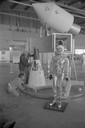
| Date: | 1965 |
|---|---|
| Description: | A traveling display about the NASA manned space program on exhibit at Austin Straubel Airport. Included in the exhibit is a model of a space capsule and a ... |
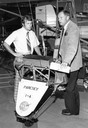
| Date: | |
|---|---|
| Description: | Astronaut Neil Armstrong (right), the first man to walk on the surface of the Moon, with Tom Poberezny, the son of EAA founder Paul Poberezny and the presi... |

| Date: | 1893 |
|---|---|
| Description: | Front and back covers of an advertising brochure for the New Empire line of mowers, reapers and grain binders manufactured by J.F. Seiberling & Company. Th... |

| Date: | 1684 |
|---|---|
| Description: | Map of North America showing some colonies, cities, rivers, lakes, and Native American land. Ship routes spread across both oceans, including one decorated... |

| Date: | 1713 |
|---|---|
| Description: | Map showing the regions explored by Robert de La Salle between 1681 and 1686, as well as the route La Salle, and later Henri Joutel, took, moving north fro... |

| Date: | 1759 |
|---|---|
| Description: | Map of north eastern Canada and parts of New England, showing settlements, cities, portages, Native American land, mountains, lakes, and rivers. The unusua... |

| Date: | 1720 |
|---|---|
| Description: | Detailed, ornate, and comprehensive map of America from the east coast to present day Texas. Numerous features appear throughout the map, including Native ... |
If you didn't find the material you searched for, our Library Reference Staff can help.
Call our reference desk at 608-264-6535 or email us at: