 Filter: Categories of Wisconsin Historical Images
Filter: Subject of Clothing and dress
Filter: Subject of science
Filter: Subject of birds
Filter: Categories of Wisconsin Historical Images
Filter: Subject of Clothing and dress
Filter: Subject of science
Filter: Subject of birds

| Date: | 03 07 1945 |
|---|---|
| Description: | Robert McCabe, University of Wisconsin Arboretum biologist, and Jim Hale, his assistant, study the band on one of the pheasants caught in the trap in the b... |
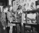
| Date: | 04 13 1948 |
|---|---|
| Description: | Fourth grade students at Emerson Elementary School, 2421 East Johnson Street, shown examining stuffed birds in the school's science room. Left to right: Da... |

| Date: | 1746 |
|---|---|
| Description: | Detailed map of the western hemisphere and part of Africa and Europe. Islands, cities, settlements, rivers, lakes, countries, and regions are marked. Mount... |

| Date: | 1720 |
|---|---|
| Description: | Detailed, ornate, and comprehensive map of America from the east coast to present day Texas. Numerous features appear throughout the map, including Native ... |
If you didn't find the material you searched for, our Library Reference Staff can help.
Call our reference desk at 608-264-6535 or email us at: