Filter: Categories of Wisconsin Historical Images
Filter: Subject of Clothing and dress
Filter: Subject of rivers
Filter: Subject of birds
Filter: Categories of Wisconsin Historical Images
Filter: Subject of Clothing and dress
Filter: Subject of rivers
Filter: Subject of birds
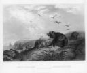
| Date: | 11 25 1871 |
|---|---|
| Description: | Engraved view of Peshtigo Fire showing people trying to escape the flames by boat and on horseback. A team of cattle also seek refuge and several birds tak... |

| Date: | 1886 |
|---|---|
| Description: | Advertisement for the Atchison, Topeka and Santa Fe Railroad featuring an illustration of Uncle Sam stretched from the Missouri River to the Pacific Ocean.... |

| Date: | 1870 |
|---|---|
| Description: | Bird's-eye view of Whitewater, with insets. |
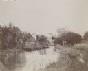
| Date: | |
|---|---|
| Description: | A man, possibly J. Schildhauer, stands at the edge of a small river with his hands on his hips. A dog is standing at the river's edge looking at a flock of... |

| Date: | 1968 |
|---|---|
| Description: | Two passengers stand over a bench and look out of the ferry towards the water. The developed shoreline and a pier with a seagull perched on top can be see... |

| Date: | 1696 |
|---|---|
| Description: | Engraved and hand-colored map of Ethiopia, from Blaeu's General Atlas. Map title is framed by a man and a woman, both wearing head turbans, who are standin... |
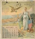
| Date: | 1893 |
|---|---|
| Description: | Calendar front, with the month of January, 1893. At the top it reads: "1893 calendar presented to the farmers of the world with the compliments of Aultman,... |
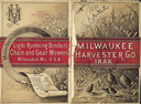
| Date: | 1888 |
|---|---|
| Description: | Front and back cover of catalog, featuring on the front an illustration of birds, mice, and flying insects near a wheat field. The back cover reads: "Manuf... |

| Date: | 1746 |
|---|---|
| Description: | Detailed map of the western hemisphere and part of Africa and Europe. Islands, cities, settlements, rivers, lakes, countries, and regions are marked. Mount... |

| Date: | 1719 |
|---|---|
| Description: | Map of North America showing land divisions between France, Spain, England, Sweden, Denmark and Holland. The map is detailed, labeling cities, forts, islan... |

| Date: | 1720 |
|---|---|
| Description: | Detailed, ornate, and comprehensive map of America from the east coast to present day Texas. Numerous features appear throughout the map, including Native ... |

| Date: | 1940 |
|---|---|
| Description: | A young boy wearing knickers, high stockings and a jacket is watching two swans on the Mullet River. A bridge and the rear of commercial buildings are in t... |

| Date: | 1910 |
|---|---|
| Description: | Handwriting on front reads: "Greetings from Prairie Du Sac, Wis." and "Merry Christmas". A scene of a man on the shoreline of a river with a small boat. Sw... |
If you didn't find the material you searched for, our Library Reference Staff can help.
Call our reference desk at 608-264-6535 or email us at: