 Filter: Categories of Wisconsin Historical Images
Filter: Subject of Clothing and dress
Filter: Subject of mountains
Filter: Subject of ships
Filter: Categories of Wisconsin Historical Images
Filter: Subject of Clothing and dress
Filter: Subject of mountains
Filter: Subject of ships

| Date: | 1893 |
|---|---|
| Description: | Front and back covers of an advertising brochure for the New Empire line of mowers, reapers and grain binders manufactured by J.F. Seiberling & Company. Th... |
| Date: | |
|---|---|
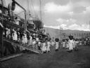
| Description: | Women loading cargo onto a U.S. ship at St. Thomas in the Virgin Islands by way of baskets balanced on the tops of their heads. |

| Date: | 09 1951 |
|---|---|
| Description: | A sampan boat in Hong Kong harbor. Perhaps what caught the photographer's eye was the laundry on the boat hanging out to dry. |

| Date: | 03 24 1950 |
|---|---|
| Description: | Front cover of a farewell dinner menu from the Italian Line ship Saturnia, with two Commedia dell' Arte characters: Tartaglia, a rotund figure who w... |

| Date: | 1627 |
|---|---|
| Description: | Map of North and South America showing settlements, rivers, lakes, mountains, islands and regions of the western hemisphere. It includes an inset map of Gr... |

| Date: | 1630 |
|---|---|
| Description: | One of the few maps by Dutch cartographer Willem Blaeu depicting the Americas, this map shows regions, settlements, islands, mountains, forests, rivers, an... |

| Date: | 1684 |
|---|---|
| Description: | Map of North America showing some colonies, cities, rivers, lakes, and Native American land. Ship routes spread across both oceans, including one decorated... |

| Date: | 1770 |
|---|---|
| Description: | Map of North America from the Great Lakes to the northern portion of South America. It shows cities, Native American land, mountains, swamps, lakes, rivers... |

| Date: | 1759 |
|---|---|
| Description: | Map of north eastern Canada and parts of New England, showing settlements, cities, portages, Native American land, mountains, lakes, and rivers. The unusua... |

| Date: | 1755 |
|---|---|
| Description: | Map of Virginia and parts of Maryland, North Carolina, and New Jersey. It shows borders, boundary lines, some Native American land, counties, cities, towns... |

| Date: | 1935 |
|---|---|
| Description: | Elevated view of men, women and children ready to disembark ship. Original caption reads: "Determination to make good is written on the faces of the Wiscon... |
If you didn't find the material you searched for, our Library Reference Staff can help.
Call our reference desk at 608-264-6535 or email us at: