 Filter: Categories of Wisconsin Historical Images
Filter: Subject of Clothing and dress
Filter: Subject of islands
Filter: Subject of political science
Filter: Categories of Wisconsin Historical Images
Filter: Subject of Clothing and dress
Filter: Subject of islands
Filter: Subject of political science
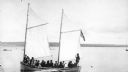
| Date: | 1900 |
|---|---|
| Description: | Group of people on sailboat "Alpha" at dock on Madeline Island. Captain Daniel Angus is at the tiller. |

| Date: | |
|---|---|
| Description: | Wadmalaw Island Citizenship group participants in the midst of a session. |

| Date: | 1967 |
|---|---|
| Description: | Nelson sits in a canoe and looks out over the water around the Apostle Islands. |
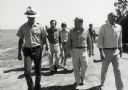
| Date: | 1979 |
|---|---|
| Description: | Senator Gaylord Nelson, Dave Obey, and Secretary of the Interior Cecil Andrus, walk along a beach with a park ranger during a tour of the Apostle Islands. ... |

| Date: | 1945 |
|---|---|
| Description: | Marines use an International TD-9 crawler tractor (TracTracTor) with a dozer shovel loader to fill a truck parked on a beach. A ship is in the water behind... |

| Date: | 1712 |
|---|---|
| Description: | Engraved double-hemispherical world map by Moll, included in his atlas The world described, or, A new and correct sett of maps: shewing the kingdoms and st... |

| Date: | 1740 |
|---|---|
| Description: | Engraved and hand-colored map of the Iberian peninsula as a theater of war during the War of the Spanish Succession (1701-1714). The map is dedicated to Ki... |

| Date: | 07 2001 |
|---|---|
| Description: | David Obey poses with Park Ranger Geoffrey Smith on the left and Martin Hanson on the right. They are standing on the beach with water and land in the back... |

| Date: | 1780 |
|---|---|
| Description: | Map of North and South America, showing the boundaries of colonial territories, cities, settlements, rivers, lakes, and Native American land. Particular em... |

| Date: | 1719 |
|---|---|
| Description: | Map of North America showing land divisions between France, Spain, England, Sweden, Denmark and Holland. The map is detailed, labeling cities, forts, islan... |

| Date: | 1770 |
|---|---|
| Description: | Map of North America from the Great Lakes to the northern portion of South America. It shows cities, Native American land, mountains, swamps, lakes, rivers... |
| Date: | 1898 |
|---|---|
| Description: | I.P. Rumsey is raising the Island Lodge flag. Caption reads: "Up with the flag! I.P. Rumsey." |

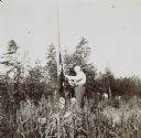
| Date: | 1910 |
|---|---|
| Description: | With shovels in hand, a man, woman, and boy are digging a hole in the ground for a flag pole. One young man is holding the pole in place with two hands. A... |

| Date: | 1913 |
|---|---|
| Description: | W.A. Holt and his children are standing by the flag pole, with the American flag flying. Names from left to right: Alfred Holt, W.A. Holt, Donald Holt, Jea... |
| Date: | 1902 |
|---|---|
| Description: | The American flag, twisted around the wooden pole on the Island, is the focal point this picture. Lucy and W.A. Holt with their children are standing to th... |

| Date: | 08 1922 |
|---|---|
| Description: | View of Henry Rumsey's boat house, which is built of logs. An American flag is flying from the flagpole at the front of the boathouse. |

| Date: | 08 1914 |
|---|---|
| Description: | Looking at the camera, G.F. Loomis is sitting in the front of boat, on the far left. In total, there are 4 boats arriving at Picnic Island on Archibald Lak... |

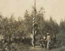
| Date: | 07 26 1918 |
|---|---|
| Description: | Most of the Lucy and W.A. Holt family are gathered around the Islander flag, which appears to be new. All of the children are present except Alfred Holt. T... |

| Date: | 07 29 1920 |
|---|---|
| Description: | It is time to raise or lower the American Flag by members of the Holt family during their stay on the Island at Archibald Lake. |

| Date: | 1956 |
|---|---|
| Description: | Three boys lawn bowling on the bowling green next to Lake Namakagon; the Forest Lodge Boathouse and Champagne Island are in the background. |
If you didn't find the material you searched for, our Library Reference Staff can help.
Call our reference desk at 608-264-6535 or email us at: