 Filter: Categories of Wisconsin Historical Images
Filter: Subject of Clothing and dress
Filter: Subject of intellectual life
Filter: Subject of exploration
Filter: Categories of Wisconsin Historical Images
Filter: Subject of Clothing and dress
Filter: Subject of intellectual life
Filter: Subject of exploration

| Date: | 08 17 1965 |
|---|---|
| Description: | NBC News broadcaster Merrill Mueller interviewing Lockheed engineer Bud Zeller about the Gemini Agena Target Vehicle. The interview was part of a public re... |
| Date: | |
|---|---|
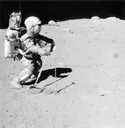
| Description: | Astronaut Charles M Duke, Jr., collecting lunar samples using a rake and tongs. This photograph was taken on the moon by John W. Young, the crew commander.... |

| Date: | 1965 |
|---|---|
| Description: | A traveling display about the NASA manned space program on exhibit at Austin Straubel Airport. Included in the exhibit is a model of a space capsule and a ... |

| Date: | 1893 |
|---|---|
| Description: | Front and back covers of an advertising brochure for the New Empire line of mowers, reapers and grain binders manufactured by J.F. Seiberling & Company. Th... |
| Date: | 10 24 1962 |
|---|---|
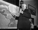
| Description: | Senator Alexander Wiley posing with a model of a missile pointed at a map of Cuba. |

| Date: | 08 22 1961 |
|---|---|
| Description: | Portrait of Dr. Krafft A. Ehricke, program director of the astronautics division of General Dynamics Corporation. He spoke at the Wisconsin Union Theater t... |

| Date: | 1790 |
|---|---|
| Description: | An updated and corrected version of Robert de Vaugondy's 1750 map "Amérique Septentrionale: Dressée sur les Relations les Plus Modernes des Voyageurs et Na... |

| Date: | 1676 |
|---|---|
| Description: | Detailed map of North and South America. Cities, towns, forests, and mountains are shown pictorially. Duval labels regions, islands, cities, lakes, and Nat... |

| Date: | 1746 |
|---|---|
| Description: | Detailed map of the western hemisphere and part of Africa and Europe. Islands, cities, settlements, rivers, lakes, countries, and regions are marked. Mount... |

| Date: | 1684 |
|---|---|
| Description: | Map of North America showing some colonies, cities, rivers, lakes, and Native American land. Ship routes spread across both oceans, including one decorated... |

| Date: | 1710 |
|---|---|
| Description: | Map of North America showing the European claims, Native American land and villages, rivers, lakes, cities, and notes on explorers, discoveries, and topogr... |

| Date: | 1713 |
|---|---|
| Description: | Map showing the regions explored by Robert de La Salle between 1681 and 1686, as well as the route La Salle, and later Henri Joutel, took, moving north fro... |

| Date: | 1759 |
|---|---|
| Description: | Map of north eastern Canada and parts of New England, showing settlements, cities, portages, Native American land, mountains, lakes, and rivers. The unusua... |

| Date: | 1720 |
|---|---|
| Description: | Detailed, ornate, and comprehensive map of America from the east coast to present day Texas. Numerous features appear throughout the map, including Native ... |
If you didn't find the material you searched for, our Library Reference Staff can help.
Call our reference desk at 608-264-6535 or email us at: