 Filter: Categories of Wisconsin Historical Images
Filter: Subject of Clothing and dress
Filter: Subject of indians of north america
Filter: Subject of battles
Filter: Categories of Wisconsin Historical Images
Filter: Subject of Clothing and dress
Filter: Subject of indians of north america
Filter: Subject of battles
| Date: | 1903 |
|---|---|
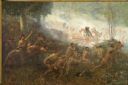
| Description: | An important event of the French and Indian War (1754-1763) was commissioned in 1903 by Robert Laird McCormick, president of the State Historical Society o... |
| Date: | 1845 |
|---|---|
| Description: | Illustration of Chippewa and Sioux Indians battling each other at the Brule River. Wood engraving from Armstrong, "Early Life Among The Indians." |
| Date: | |
|---|---|
| Description: | Painting by Cal Peters depicting the battle of Bad Axe, also known as the Bad Axe massacre, at the Mississippi River on August 2, 1832. |

| Date: | 1832 |
|---|---|
| Description: | A facsimile of an Indian painting, originally painted by the Mandan chief, Máto-Tópe. It portrays an encounter between Máto-Tópe and a Cheyenne chief. |
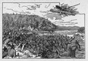
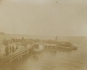
| Date: | 1898 |
|---|---|
| Description: | People on a boat dock watch a boat landing as part of the Ojibwa-Pillager Battle at Sugar Point on Bear Island. |
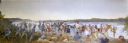
| Date: | 1898 |
|---|---|
| Description: | People on a boat dock watch a boat landing as part of the Ojibwa-Pillager Battle at Sugar Point on Bear Island. |
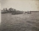
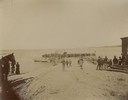
| Date: | 1898 |
|---|---|
| Description: | Cavalry on a barge are going from or returning to Bear Island at the Ojibwa-Pillager Battle at Sugar Point on Bear Island. There are buildings along the fa... |
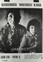
| Date: | |
|---|---|
| Description: | Poster of woman and child that says "Remember Wounded Knee". |
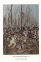
| Date: | 1982 |
|---|---|
| Description: | "The painting shows the Choctaws and a mixed group of Major Daquin's Battalion of Free Men of Color. The latter were mostly attired in civilian clothes bec... |

| Date: | 1770 |
|---|---|
| Description: | Map of North America from the Great Lakes to the northern portion of South America. It shows cities, Native American land, mountains, swamps, lakes, rivers... |

| Date: | 1609 |
|---|---|
| Description: | Illustration of an elevated view of a battle between Iroquois tribe and French on the banks of river. The Iroquois are unclothed and armed with bows and ar... |
If you didn't find the material you searched for, our Library Reference Staff can help.
Call our reference desk at 608-264-6535 or email us at: