Filter: Categories of Wisconsin Historical Images
Filter: Subject of Clothing
Filter: Subject of boats and boating
Filter: Categories of Wisconsin Historical Images
Filter: Subject of Clothing
Filter: Subject of boats and boating

| Date: | 1842 |
|---|---|
| Description: | This hand-colored lithograph of the second Fort Howard, with Indians canoeing on the Fox River, shows the hospital built 1834-1835 outside the stockade on ... |

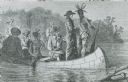
| Date: | 1835 |
|---|---|
| Description: | Little Lake Butte Des Morts just north of Lake Winnebago where Governor Lewis Cass of Michigan, and Thomas McKenney, head of the Bureau of Indian Affairs (... |

| Date: | 1784 |
|---|---|
| Description: | Plate 45. Scene from Cook's Third Expedition, 1776-1779, while in Alaska. |

| Date: | |
|---|---|
| Description: | Copy photograph of six Native American men standing outdoors wearing Sioux bonnets, and original print inscribed "Riverview Boat Line Indian Guides." Possi... |
| Date: | |
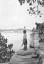
|---|---|
| Description: | A Native American Indian in native dress, including a beaded bandolier and feathered headdress, gazing out to the Wisconsin River. He is standing on a rock... |

| Date: | 1770 |
|---|---|
| Description: | Map of North America from the Great Lakes to the northern portion of South America. It shows cities, Native American land, mountains, swamps, lakes, rivers... |
If you didn't find the material you searched for, our Library Reference Staff can help.
Call our reference desk at 608-264-6535 or email us at: