 Filter: Categories of Wisconsin Historical Images
Filter: Subject of Cities and towns
Filter: Subject of writing
Filter: Categories of Wisconsin Historical Images
Filter: Subject of Cities and towns
Filter: Subject of writing
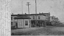
| Date: | 1905 |
|---|---|
| Description: | View down Keller Avenue towards businesses along the left. A round or octagon shaped building on the far left has a sign that reads: "Restaurant". Further ... |
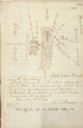
| Date: | |
|---|---|
| Description: | Drawn map of Landsford, South Carolina, from Thomas Sumter Papers. |
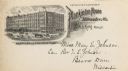
| Date: | 1910 |
|---|---|
| Description: | Postcard with engraving of the hotel in the upper left corner with a caption below that reads: "American and European Plan." Text at right reads: "If not c... |
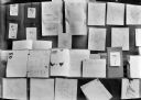
| Date: | |
|---|---|
| Description: | Display of student work including drawings, maps, and essays. |

| Date: | 1930 |
|---|---|
| Description: | The front and back of a postcard featuring a drawing of the Detroit skyline as seen from Windsor, Ontario that was sent by Alice and Floyd Quinney during t... |

| Date: | 06 1837 |
|---|---|
| Description: | Pen-and-ink on paper. Shows riverside property west of the Milwaukee River. Inscribed by several early Milwaukee settlers, including Henry W. Cleveland, Cy... |

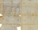
| Date: | 1848 |
|---|---|
| Description: | Pen-and-ink on paper. Includes certifications signed by "Geo R. Bluntz, District Survey of Grant Co. W.T." and Ben C. Eastman. |
| Date: | 08 1851 |
|---|---|
| Description: | Ink on paper. Includes explanation and a certification signed by Jacob Marty, Electa Marty, and a justice of the peace. Original map is very light and in f... |
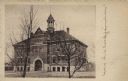
| Date: | |
|---|---|
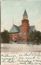
| Description: | Photographic postcard view of the exterior of the high school. There is a cupola over the belfry and an arched doorway. Caption reads: "Baldwin, Wis. High ... |
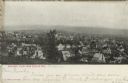
| Date: | |
|---|---|
| Description: | Photographic postcard of an elevated view of Baraboo from a hill, showing mainly dwellings. Bluffs are in the far background. Caption reads: "Baraboo, View... |
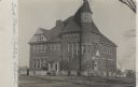
| Date: | 1906 |
|---|---|
| Description: | Photographic postcard view of the exterior of the public school, a large brick building with a turret in the corner. |
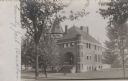
| Date: | 1906 |
|---|---|
| Description: | Photographic postcard view of the exterior of the County Jail surrounded by a lawn. A sidewalk leads to wide stone steps that rise up to an arched entrance... |
| Date: | 1906 |
|---|---|
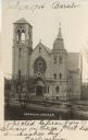
| Description: | Photographic postcard of an elevated view across street of the front of the Catholic Church, which is a large, stone building. There is a belfry on the lef... |
| Date: | 1906 |
|---|---|
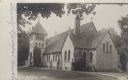
| Description: | Photographic postcard view of the exterior of the stone church. There are four crosses, one on the bell tower, and three others at the corners of the roof.... |
| Date: | 1906 |
|---|---|
| Description: | Colorized postcard of an exterior view of City Hall, a brick building with an arched entrance, a flag pole on the left, and a belfry on the right. Caption ... |
| Date: | 1910 |
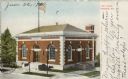
|---|---|
| Description: | Colorized postcard of a slightly elevated view of the post office. There are wide front steps up to the arched entrance from the sidewalk. The arched entra... |

| Date: | 1856 |
|---|---|
| Description: | This map of Woodman's Addition in Mineral Point is pen-and-ink on paper. The map includes certifications signed by John B. Whitelaw (surveyor), Cyrus Woodm... |

| Date: | 1856 |
|---|---|
| Description: | This map is ink and pencil on paper and shows plat of the town, local streets, and blocks and lots by number. The map includes explanatory text. |

| Date: | 11 1836 |
|---|---|
| Description: | This map is pen-and-ink on paper and is a plat of a paper city on the Wisconsin River, in what is now the Town of Dekorra. The map shows lot and block numb... |

| Date: | 06 1845 |
|---|---|
| Description: | This map is pen-and-ink on paper and shows the numbers, dimensions, and acreages of lots, as well as survey monuments and streets. Also included is a certi... |
If you didn't find the material you searched for, our Library Reference Staff can help.
Call our reference desk at 608-264-6535 or email us at: