Filter: Categories of Wisconsin Historical Images
Filter: Subject of Cities and towns
Filter: Subject of madeline island (wis.)
Filter: Categories of Wisconsin Historical Images
Filter: Subject of Cities and towns
Filter: Subject of madeline island (wis.)

| Date: | 1852 |
|---|---|
| Description: | Illustration of four Indians on Madeline Island with a canoe in the water on the shore. |

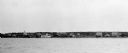
| Date: | 1910 |
|---|---|
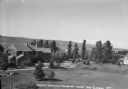
| Description: | View of La Pointe taken from Big Bay Road on Madeline Island. |
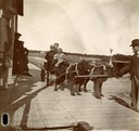
| Date: | 1912 |
|---|---|
| Description: | Child passengers being transported on a wagon pulled by dog team belonging to Thomas Stahl. Wagon and dog team are on the boardwalk in La Pointe. |

| Date: | 1905 |
|---|---|
| Description: | Indian cemetery. A large body of water is in the background. Caption reads: "Indian Burying Grounds, Bayfield, Wis." |
| Date: | 1905 |
|---|---|
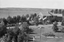
| Description: | View across water towards Old Mission, as seen from the pier with Old Mission Congregational Church behind it. This Mission was established in 1830 by Fred... |
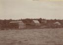
| Date: | 1930 |
|---|---|
| Description: | The Mission Dock with a large white building behind it. It is not the Old Mission House, as sometimes believed to be, and the term "Mission Dock" may not e... |
| Date: | 1915 |
|---|---|
| Description: | The Old Mission Inn by what is believed to be the first Protestant religious building in Wisconsin called Old Mission Congregational Church. |

| Date: | |
|---|---|
| Description: | The Old Mission Inn, originally built as a mission house in 1832 by the Congregational mission established by Frederick Ayer in 1830. In later years furthe... |
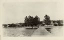
| Date: | 1938 |
|---|---|
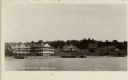
| Description: | Large vacation homes in La Pointe, Madeline Island. Bayfield is in the background on the far shore of Lake Superior. |
| Date: | 1937 |
|---|---|
| Description: | Elevated view of a woman standing on lawn of the Woods mansion on Nebraska Row. Bayfield is visible on the opposite mainland shore of Lake Superior. |

| Date: | 1981 |
|---|---|
| Description: | Plat map of Madeline Island surrounded by Basswood, Michigan and Gull Islands. |

| Date: | 1880 |
|---|---|
| Description: | This copy of an 1834 map in the American Fur Company's papers held by the New-York Historical Society shows an outline of Chequamegon Bay and Madeline Isla... |

| Date: | 1977 |
|---|---|
| Description: | This pictorial map was produced by the Chateau, a resort in La Pointe, and shows Madeline Island landmarks and tourist attractions. On the verso is the spr... |

| Date: | 1964 |
|---|---|
| Description: | This 1964 map of Madeline Island, Ashland County, Wisconsin, shows existing and historical locations, roads, the boundaries of a proposed state park, secti... |

| Date: | 1856 |
|---|---|
| Description: | This map shows land ownership by name, a plat of Bayfield, local streets, part of Lake Superior, part of Madeline Island, and part of Bass Island. La Point... |

| Date: | 1847 |
|---|---|
| Description: | This map identifies surveyed areas of the Upper Peninsula and shows lakes, rivers, and islands in portions of Wisconsin, Minnesota, Michigan, and upper Can... |

| Date: | 1959 |
|---|---|
| Description: | This map shows landownership, acreages, and old fort road on the southwest corner of Madeline Island. The map includes an explanation of survey in the midd... |
If you didn't find the material you searched for, our Library Reference Staff can help.
Call our reference desk at 608-264-6535 or email us at: