Visit our other Wisconsin Historical Society websites!
 Filter: Categories of Wisconsin Historical Images
Filter: Subject of Cities and towns
Filter: Subject of indians of north america
Filter: Categories of Wisconsin Historical Images
Filter: Subject of Cities and towns
Filter: Subject of indians of north america

| Date: | 1936 |
|---|---|
| Description: | This map is red and black ink on tracing cloth and is oriented with north to the upper left. This hand-drawn map shows a central portion of the military ro... |
| Date: | |
|---|---|
| Description: | Winter view of Chippewa (Ojibwa) Valley village. |

| Date: | 1893 |
|---|---|
| Description: | Back of painting reads: "Madison in June 1837 after photo taken by E.E. Bailey" and "Peck's cabin by Dengel." The Eben Peck cabin was the first house built... |

| Date: | |
|---|---|
| Description: | The Eben Peck cabin was the first house built in Madison. |

| Date: | 1852 |
|---|---|
| Description: | Illustration of four Indians on Madeline Island with a canoe in the water on the shore. |
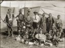
| Date: | 1908 |
|---|---|
| Description: | Ho-Chunk performers gathered behind a drum and Winnebago baskets at the 1908 Homecoming. Standing from the left are Jim Swallow (MaPaZoeRayKeKah), William ... |
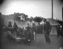
| Date: | 1908 |
|---|---|
| Description: | Ho-Chunk men and women sitting and standing around a large medicine drum in an area portioned off by canvas barriers in front of a lodge. Identified as the... |

| Date: | 1886 |
|---|---|
| Description: | This map shows U.S. land offices, completed railroads, railroad land grant limits, lakes, rivers, and Indian reservations. Communities, lakes, and rivers a... |
| Date: | 1913 |
|---|---|
| Description: | Man, most likely R.G. Brooks, showing a Milwaukee grain binder to three Native Americans in traditional dress in front of McCormick Works. One of the Nativ... |
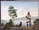
| Date: | |
|---|---|
| Description: | Watercolor of Canadian Prairie Indian at lake's shore with gun in hand and a recently hunted duck on the ground. A dog is at his feet. On the far shoreline... |

| Date: | 1873 |
|---|---|
| Description: | Bird's-eye map of La Crosse from the Mississippi River. |
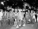
| Date: | 07 22 1932 |
|---|---|
| Description: | Group portrait of children from the South Side Franklin playground dressed as Indians surrounding a small tipi (teepee) prior to the Lantern Parade. |
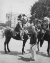
| Date: | 07 09 1930 |
|---|---|
| Description: | Mayor Albert G. Schmedeman greeting Chief Shunatuna, who is on horseback and who is in Madison with the Official United States Indian band at the RKO Orphe... |
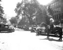
| Date: | 07 09 1930 |
|---|---|
| Description: | A man on a horse with Pontiac cars lined up on Wisconsin Avenue for the U.S. Indian Band parade, with the Wisconsin State Capitol in the background. They p... |
| Date: | |
|---|---|
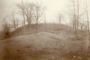
| Description: | Largest platform mound in Trempealeau as seen from the north. |
| Date: | |
|---|---|
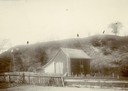
| Description: | View of large platform mound with small barn in the foreground. The numbers 1, 2, and 3 are written on the photograph in ink. |

| Date: | |
|---|---|
| Description: | Sign above the main entrance of the Oshkosh Brewing Company, which uses an illustration of Chief Oshkosh as part of its logo. The sign was installed there... |

| Date: | 1655 |
|---|---|
| Description: | Map of Virginia Coast based on observations by Captain John Smith. |
| Date: | 1655 |
|---|---|
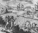
| Description: | Scene of the Jamestown Settlement in Virginia, ca. 1614 showing men at the water's edge being beckoned by mermaids. |
| Date: | |
|---|---|
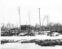
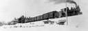
| Description: | View from bottom of snowy hill looking up towards the Wisconsin & Northern Railroad engine #3, which was purchased from the Grand Rapids & Indiana Railway. |
If you didn't find the material you searched for, our Library Reference Staff can help.
Call our reference desk at 608-264-6535 or email us at: