 Filter: Categories of Wisconsin Historical Images
Filter: Subject of Cities and towns
Filter: County of Sauk
Filter: Year of 1800-1899
Filter: Categories of Wisconsin Historical Images
Filter: Subject of Cities and towns
Filter: County of Sauk
Filter: Year of 1800-1899

| Date: | 1870 |
|---|---|
| Description: | Baraboo was first settled around 1838, and by 1870 it had become the county seat and the thriving village illustrated here. This birds eye drawing depicts ... |

| Date: | 1870 |
|---|---|
| Description: | Bird's-eye map of Prairie du Sac. |

| Date: | 1874 |
|---|---|
| Description: | Bird's-eye map of Reedsburg, on the Baraboo River. |

| Date: | 1870 |
|---|---|
| Description: | Sauk City is the oldest incorporated village in Wisconsin (incorporated in 1854) and also has the oldest organized volunteer fire department in the state, ... |

| Date: | 1883 |
|---|---|
| Description: | Bird's-eye map of Prairie du Sac, Wisconsin with an inset of Clifton. |

| Date: | 1883 |
|---|---|
| Description: | Bird's-eye map of Sauk City. |

| Date: | 1886 |
|---|---|
| Description: | Bird's-eye map of Baraboo with inset of Devil's Lake, the south and east sides of the commercial square, the First National Bank, and the Warren House hote... |
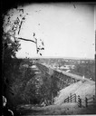
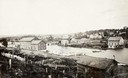
| Date: | 1873 |
|---|---|
| Description: | View, from the south bank of the Wisconsin River, looking towards Merrimac, Sauk County. People are standing on the 1899-foot railroad bridge, which runs ... |
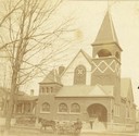
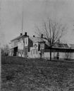
| Date: | 1894 |
|---|---|
| Description: | View of the German Methodist Church with George Bowers, a milkman, standing in the foreground. |
| Date: | 1870 |
|---|---|
| Description: | View of Baraboo high school with a large group of students standing around it. |
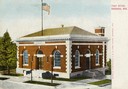
| Date: | 1895 |
|---|---|
| Description: | Elevated view across street towards the post office. Caption reads: "Post Office, Baraboo, Wis." |
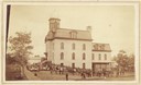
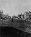
| Date: | 1868 |
|---|---|
| Description: | View of the Baraboo River and surrounding structures. |

| Date: | 1859 |
|---|---|
| Description: | Map featuring various views of buildings and scenes from Sauk County. |
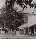
| Date: | 1875 |
|---|---|
| Description: | View of the west side of Water Street. |
| Date: | 1880 |
|---|---|
| Description: | View of unpaved Water Street, featuring a group of patrons standing in the entrance of A. Becker's Saloon. |
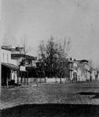
| Date: | 1868 |
|---|---|
| Description: | View of the west side of unpaved Water Street, looking south. |
| Date: | 1868 |
|---|---|
| Description: | View of unpaved Water Street, showing a millinery shop. |
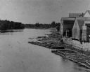
| Date: | 1880 |
|---|---|
| Description: | Elevated view of the Wisconsin River shoreline, showing lumber rafts "tied up over Sunday." |
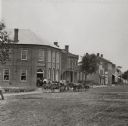
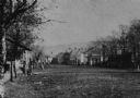
| Date: | 1868 |
|---|---|
| Description: | View of Water Street looking north from the business district. |
| Date: | 1875 |
|---|---|
| Description: | View of unpaved Water Street south of the Highway 12 intersection, looking north. Bluffs are in the distance. |
If you didn't find the material you searched for, our Library Reference Staff can help.
Call our reference desk at 608-264-6535 or email us at: