 Filter: Categories of Wisconsin Historical Images
Filter: Subject of Cities and towns
Filter: Community of Prairie du Chien
Filter: Creator Name of Unknown
Filter: Categories of Wisconsin Historical Images
Filter: Subject of Cities and towns
Filter: Community of Prairie du Chien
Filter: Creator Name of Unknown

| Date: | 1858 |
|---|---|
| Description: | This map shows streets, lots, and landownership. Also included are notations in pencil and blue colored pencil. Some lots are colored in blue, green, or br... |
| Date: | |
|---|---|
| Description: | This map shows farm lots and private land claims on Prairie du Chien. The bottom left margin reads: "Part of sec. 1, T6 N, R 7W and sec. 36, T 7N, R 7W. S... |

| Date: | 1865 |
|---|---|
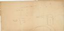
| Description: | This is a collection of two plat maps. The first map shows lots, streets, and farm lot 25. Written in ink, the top of the map reads: Plat of Prairie du Chi... |

| Date: | 1856 |
|---|---|
| Description: | This map shows lot and block numbers, streets, depot building, and the Milwaukee & Mississippi Rail Road. |

| Date: | 05 21 1855 |
|---|---|
| Description: | This plat map shows lots, the Kickapoo River, and the Wisconsin River. |
| Date: | 1856 |
|---|---|
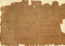
| Description: | This map is ink and watercolor on paper and includes certifications inscribed by Saml. T. [M?]ight, a civil engineer, Edward H. Brodhead, James H. Lockwood... |

| Date: | |
|---|---|
| Description: | This map is pen-and-ink on tracing paper with a mounted legend and shows the Kickapoo River, Indian mounds, the 1st Fort Crawford, an Indian Agency, the si... |

| Date: | 1900 |
|---|---|
| Description: | This photocopy map shows proposed buildings and building use at Fort Crawford. |

| Date: | 1900 |
|---|---|
| Description: | This photocopy map shows marshes, woods, buildings, and selected features including islands, mounds, old Fort Crawford, and "new site for a fort in questio... |
| Date: | 1930 |
|---|---|
| Description: | This photocopy map includes cross section of buildings. |
If you didn't find the material you searched for, our Library Reference Staff can help.
Call our reference desk at 608-264-6535 or email us at: