 Filter: Categories of Wisconsin Historical Images
Filter: Subject of Cities and towns
Filter: Community of Green Bay
Filter: Year of 1800-1899
Filter: Categories of Wisconsin Historical Images
Filter: Subject of Cities and towns
Filter: Community of Green Bay
Filter: Year of 1800-1899
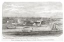
| Date: | 1876 |
|---|---|
| Description: | View looking southeast over river from Elmore and Kelly's Elevator. |
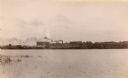
| Date: | 1889 |
|---|---|
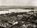
| Description: | View of Green Bay from the Fort Howard side of the Fox River. |
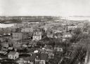
| Date: | 1889 |
|---|---|
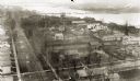
| Description: | Elevated view looking north toward the harbor with multiple buildings in the foreground. |
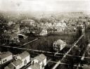
| Date: | 1889 |
|---|---|
| Description: | Elevated view of South Jefferson and Doty Streets, showing the Albert Weiss and Platt Greene residences and the present location of the Columbus Club, Kell... |
| Date: | 1889 |
|---|---|
| Description: | View of Green Bay from the top of St. Willibrord's Church. A river can be seen in the background. |
| Date: | 1889 |
|---|---|
| Description: | Southwest view of the Fox River and the waterfront. |
| Date: | 1889 |
|---|---|
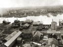
| Description: | Elevated view of an industrial waterfront along the Fox River. |

| Date: | 1889 |
|---|---|
| Description: | View of the Fox River between Green Bay and Fort Howard. |
| Date: | 1898 |
|---|---|
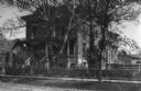
| Description: | Albert Weise's residence, with wooden sidewalk, and two kids standing on the front porch posing for the photographer. |

| Date: | 1895 |
|---|---|
| Description: | Daniel H. and Joshua Whitney's residence located at 402 Main Street at the intersection of Monroe Avenue. The house was torn down in 1897. |

| Date: | 1821 |
|---|---|
| Description: | Plan of the settlement of Green Bay. |
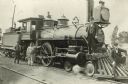
| Date: | 1896 |
|---|---|
| Description: | Railroad employees pose with locomotive engine no. 925 of the Chicago, Milwaukee & St. Paul Railway. The engine has a long pilot, a large oil headlight, sm... |

| Date: | 1835 |
|---|---|
| Description: | Ink on tracing paper map of Green Bay, Wisconsin and nearby areas, Lake Winnebago, Fox and Wolf Rivers, and the junctions of the Mississippi and Wisconsin ... |

| Date: | 1836 |
|---|---|
| Description: | This manuscript shows the 1835 survey of the road corresponding approximately to a portion of County Trunk A in the Town of Scott, Brown County, Wisconsin.... |

| Date: | 08 27 1825 |
|---|---|
| Description: | Map is ink on paper. Map shows plat of the town of Munnomunne, the Fox River, farm lots, and an established highway. The map is signed by "J.D. Doty, Propr... |

| Date: | 1836 |
|---|---|
| Description: | This map of Navarino shows a development plat of the village situated opposite Fort Howard at mouth of the Fox River. The names of proprietors are listed a... |

| Date: | 1856 |
|---|---|
| Description: | This map shows a plat of town, local streets, and parts of East and Fox Rivers. |

| Date: | 1868 |
|---|---|
| Description: | This map shows land ownership by name, lots, roads, railroads, and part of the Fox River. The map includes an explanation and table of witnesses to the cor... |

| Date: | 1874 |
|---|---|
| Description: | This map shows streets, buildings, railroads, the Fox River, the East River, and part of Green Bay. |

| Date: | 1862 |
|---|---|
| Description: | This map shows landownership on a military reserve, private claims, buildings (including Fort Howard and U.S. sawmill), swamps, public barns and fields, an... |
If you didn't find the material you searched for, our Library Reference Staff can help.
Call our reference desk at 608-264-6535 or email us at: