 Filter: Categories of Wisconsin Historical Images
Filter: Subject of Cities and towns
Filter: Community of Blue Mounds
Filter: Categories of Wisconsin Historical Images
Filter: Subject of Cities and towns
Filter: Community of Blue Mounds
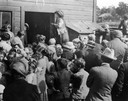
| Date: | 1915 |
|---|---|
| Description: | Belle Case La Follette, wife of Robert M. La Follette, Sr., addressing a group of farmers during a tour on the Chautauqua circuit during which she frequent... |
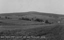
| Date: | |
|---|---|
| Description: | View of farmland near Blue Mounds, with possibly property markers horizontal, across the center, and some distant farm houses and a barn. Caption reads: "B... |
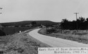
| Date: | |
|---|---|
| Description: | View of rural Blue Mounds, with a two-lane, paved road. The caption at the bottom reads: "East View of Blue Mounds, Wis. Elevation, 1760 ft.". |
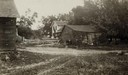
| Date: | 06 1925 |
|---|---|
| Description: | View of three farm buildings - the one in the center is collapsing. |
| Date: | 1910 |
|---|---|
| Description: | View of a main street during the winter. One horse is covered with a horse blanket. Caption reads: "Winter Scene at Blue Mounds Wis." |
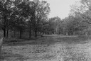
| Date: | 1930 |
|---|---|
| Description: | View of a wide path through trees in the spring or summer. |

| Date: | 1930 |
|---|---|
| Description: | Remains of the racetrack on the top of Blue Mound. |
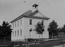
| Date: | |
|---|---|
| Description: | Spring or summer view of a large, white school house, and a few trees in front of it. Caption reads: "School, Blue Mounds, Wis." |
| Date: | 1910 |
|---|---|
| Description: | Distant view of the town, with railroad tracks in foreground. The church is the highest point in the image. "General View. Blue Mounds in the Distance. Alt... |
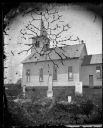
| Date: | 1876 |
|---|---|
| Description: | East Blue Mounds Lutheran Church, formerly Norsk Evangelisk Kirke, built in 1868. The graves of Andreas L. Dahl's mother, Berthe Nelsdatter (Lund) Dahlen, ... |

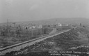
| Date: | 1930 |
|---|---|
| Description: | Aerial view of the town, including the central business district. |

| Date: | 1925 |
|---|---|
| Description: | A view of Tenpin Alley (rear) active in lead mining days. |
| Date: | 1925 |
|---|---|
| Description: | A view of the front of Tenpin Alley, active in lead mining days. |

| Date: | 1925 |
|---|---|
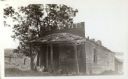
| Description: | This building was said to have been an early residence. |

| Date: | 1925 |
|---|---|
| Description: | Adams house and store. John Adams sold pork, flour, and other merchandise during mining days. Said to be the birthplace of Aliva Adams, afterwards the Gove... |
| Date: | |
|---|---|
| Description: | A snow-covered street with several horses standing at the curb. Groups of people pose on the porches of the hotel and the post office. |

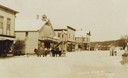
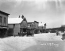
| Date: | |
|---|---|
| Description: | A view of a retail street from the intersection. From the corner of the street, there is a restaurant, hotel, and post office. On the sidewalk, men sit on ... |
| Date: | 1930 |
|---|---|
| Description: | Bird's-eye view town. There are barns, homes, a church's steeple and a lumberyard. |

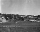
| Date: | |
|---|---|
| Description: | View of the village from the railroad tracks. There is a church among the cluster of homes. |

| Date: | |
|---|---|
| Description: | View looking down hill of several buildings. More hills are in the far background. Caption reads: "Blue Mounds at a Distance, Altitude 1760 FT." |
If you didn't find the material you searched for, our Library Reference Staff can help.
Call our reference desk at 608-264-6535 or email us at: