Filter: Categories of Wisconsin Historical Images
Filter: Subject of Church buildings
Filter: Year of 1800-1899
Filter: County of Waukesha
Filter: Categories of Wisconsin Historical Images
Filter: Subject of Church buildings
Filter: Year of 1800-1899
Filter: County of Waukesha

| Date: | 1886 |
|---|---|
| Description: | Bird's-eye map of Menomonee Falls. |

| Date: | 1880 |
|---|---|
| Description: | Bird's-eye map of Waukesha, county seat of Waukesha County. |

| Date: | 1870 |
|---|---|
| Description: | Birds-eye drawing of Oconomowoc depicts street names and street layouts, houses, trees, Oconomowoc River, Fowler Lake, and La Belle Lake. A reference key a... |

| Date: | 1874 |
|---|---|
| Description: | Bird's-eye view of Waukesha, looking southwest, with insets of State Industrial School, Court House, and Fountain Spring House. |
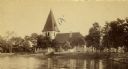
| Date: | 1863 |
|---|---|
| Description: | Exterior of St. John Chrysostom Episcopal Church, with trees and a fence in the foreground. |
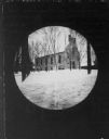
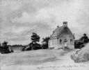
| Date: | 1890 |
|---|---|
| Description: | Round-framed view of Stone Church, built by Rev. A.L. Lindsley. |
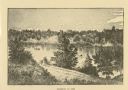
| Date: | 1876 |
|---|---|
| Description: | Distant view of Neshotah Mission. River with boaters, two people standing on riverbank, mission on hill in background. |
| Date: | 1851 |
|---|---|
| Description: | School and church, from a drawing by Johann B. Wengler, an Austrian traveller in this country. |
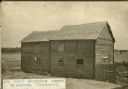
| Date: | 1894 |
|---|---|
| Description: | First Norwegian church in Wisconsin. |

| Date: | 1873 |
|---|---|
| Description: | This late 19th century map shows the lake region around Oconomowoc in Waukesha County and eastern Jefferson County, Wisconsin. The township and range grid,... |

| Date: | 1891 |
|---|---|
| Description: | This late 19th century map shows the lake region around Oconomowoc in Waukesha County and eastern Jefferson County, Wisconsin. The township and range grid,... |

| Date: | 1876 |
|---|---|
| Description: | This late 19th century map by Increase Lapham shows the lake region around Oconomowoc in Waukesha County and eastern Jefferson County, Wisconsin. Cities an... |

| Date: | 1887 |
|---|---|
| Description: | This late 19th century map shows the lake region around Oconomowoc in Waukesha County and eastern Jefferson County, Wisconsin. Cities and villages, roads, ... |

| Date: | 1898 |
|---|---|
| Description: | Map showing the contour depths of the lakes in northwestern Waukesha County, Wisconsin. Roads, railroads, depots, churches, schools, and hotels in the area... |
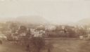
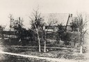
| Date: | 1890 |
|---|---|
| Description: | Elevated view of Falls Village from the cemetery looking south. |
If you didn't find the material you searched for, our Library Reference Staff can help.
Call our reference desk at 608-264-6535 or email us at: