 Filter: Categories of Wisconsin Historical Images
Filter: Subject of Church buildings
Filter: Subject of piers
Filter: Categories of Wisconsin Historical Images
Filter: Subject of Church buildings
Filter: Subject of piers
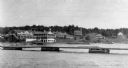
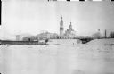
| Date: | 1920 |
|---|---|
| Description: | View from the water of the Mission, dock, Mission cottages, and Congregational Church on Madeline Island. |

| Date: | 1886 |
|---|---|
| Description: | Bird's-eye view of Bayfield, county seat of Bayfield County. On the lower left side is an inset for Bayfield and the Apostle Islands. |

| Date: | 1883 |
|---|---|
| Description: | Bird's-eye map of Superior, county seat of Douglas County, on the shores of Lake Superior, with insets of points of interest. |

| Date: | 1879 |
|---|---|
| Description: | Bird's-eye map of Two Rivers. |

| Date: | 1896 |
|---|---|
| Description: | Bird's-eye view of Washburn, with twenty vignettes around side, water in foreground with docks and lumber corral. Thirty-three locations identified in key ... |

| Date: | 1892 |
|---|---|
| Description: | Bird's-eye view of Chicago, with ships in the Lake Michigan harbor. |
| Date: | 1858 |
|---|---|
| Description: | View from the second story of the Salesianum, the residence of Dr. Salzmann. The view includes Lake Michigan, the Milwaukee shoreline, and some of the nume... |
| Date: | 1910 |
|---|---|
| Description: | Mrs. Lathrop, the town post mistress, pushing her wheelbarrow down a long wooden dock at La Pointe. She is on her way to haul merchandise for her store. |
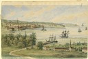
| Date: | 08 24 1885 |
|---|---|
| Description: | Pencil on paper; promontory shoreline with houses, trees, and church in background sweeping to right, with long pier jutting into lake. Two boats tied to ... |
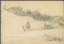
| Date: | |
|---|---|
| Description: | View of the Old Toll Bridge with trees and a pier in the foreground and buildings on the opposite shore. |
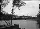
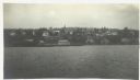
| Date: | 1937 |
|---|---|
| Description: | View from the lake of the summer homes on Nebraska Row along the shoreline of Lake Superior. The water tower and church steeple are visible on the far righ... |
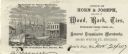
| Date: | |
|---|---|
| Description: | Letterhead of the Horn's Pier (Door County) office of Horn & Joseph, dealers in general merchandise, including "Wood, Bark, Ties, Telegraph Poles, Posts, &... |
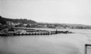
| Date: | 1924 |
|---|---|
| Description: | Elevated view over water of the harbor and buildings of Frankfort. There is a deteriorating pier in the foreground. |

| Date: | 1905 |
|---|---|
| Description: | This early 20th century map of Door County, Wisconsin, shows the township and range grid, towns, sections, cities and villages, landownership and acreages,... |

| Date: | |
|---|---|
| Description: | Photographic postcard of a compilation of three views from around Berlin. Includes a view of a house near the river, a steamboat on the river, and a snow-c... |
| Date: | 1918 |
|---|---|
| Description: | View across snowy ground towards the United States hospital and Army Headquarters for American forces deployed as a part of the Allied Intervention in Nort... |
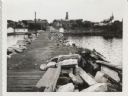
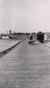
| Date: | 09 14 1962 |
|---|---|
| Description: | View from pier, lined with rocks, towards town. There are industrial buildings along the shoreline, and up a small rise is a building with a tower, and on ... |
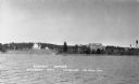
| Date: | 1916 |
|---|---|
| Description: | View across Lake Superior towards Bayfield. |

| Date: | 1900 |
|---|---|
| Description: | Elevated view across canal towards McCormick works. There are piles of parts along the shipping dock. A large church building is in the far distance. |
If you didn't find the material you searched for, our Library Reference Staff can help.
Call our reference desk at 608-264-6535 or email us at:
