 Filter: Categories of Wisconsin Historical Images
Filter: Subject of Church buildings
Filter: Subject of human settlements
Filter: Subject of food industry and trade
Filter: Categories of Wisconsin Historical Images
Filter: Subject of Church buildings
Filter: Subject of human settlements
Filter: Subject of food industry and trade
| Date: | |
|---|---|
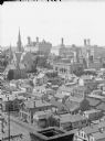
| Description: | View of buildings from the dome of the Exposition building, including a church and the Best Brewing Company in the distance. |

| Date: | 1898 |
|---|---|
| Description: | Bird's-eye map of Milwaukee with prominent streets and buildings identified. Taken from City Hall Tower. |

| Date: | 1882 |
|---|---|
| Description: | This map of Cedarburg is a bird's-eye map with an inset of Cedarburg Brewery. Relief is shown pictorially and the map includes an index to buildings. |

| Date: | 1878 |
|---|---|
| Description: | Bird's-eye map of Chilton with insets of points of interest, including P.H. Becker's Brewery, Chilton House, and Gutheil's Block. |

| Date: | 1880 |
|---|---|
| Description: | Bird's-eye map over the Mississippi River of Fountain City. Paddle steamers and steamboats are on the river, and bluffs are in the background. |

| Date: | 1871 |
|---|---|
| Description: | Birds eye map of Monroe, WI, depicts street names and street locations, houses, and trees. A reference key at the bottom of the map shows the locations of ... |
| Date: | 1862 |
|---|---|
| Description: | John S. Fuller took this image of the third Wisconsin State Capitol (the second in Madison), from Governor Farwell's Octagon House, probably early in 1862.... |
| Date: | 1863 |
|---|---|
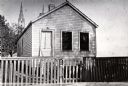
| Description: | Exterior view of M. Gottshalk's first meat market. |
| Date: | 06 22 1919 |
|---|---|
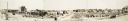
| Description: | Panoramic view of Fergus Falls after a cyclone ravaged it. Grand Hotel (middle), and Catholic Church (right), have been labeled. Red River Milling Company ... |
| Date: | 1969 |
|---|---|
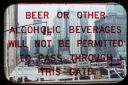
| Description: | A notification is on a window that reads, "Beer or other alcoholic beverages will not be permitted to pass through this gate." Beyond the gate, the World T... |
| Date: | 1964 |
|---|---|
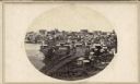
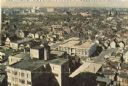
| Description: | Elevated view of city looking west, showing breweries and the center of the city. |

| Date: | 1874 |
|---|---|
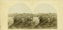
| Description: | Stereograph of elevated view looking northwest from Exposition Building. There is a church on a street corner on the left, and the Best Brewing Company in ... |
| Date: | 1862 |
|---|---|
| Description: | The third Wisconsin State Capitol (the second in Madison), from Governor Farwell's Octagon House, probably early in 1862. Also visible in the downtown are ... |

| Date: | 1874 |
|---|---|
| Description: | Stereograph of elevated view looking northwest from Exposition Building. There is a church on a street corner on the left, and the Best Brewing Company in ... |

| Date: | 1896 |
|---|---|
| Description: | A hand-colored Map of Jefferson County, Wisconsin, shows township and section divisions, towns, villages and post offices, rural residents, railroads, road... |

| Date: | 1909 |
|---|---|
| Description: | A map of Langlade County, Wisconsin that shows townships and ranges, towns, cities and villages, wagon roads, churches, schools, sawmills, town halls, chee... |

| Date: | 1915 |
|---|---|
| Description: | This 1915 map of Lincoln County, Wisconsin, shows the township and range grid, towns, cities and villages, lakes and streams, residences, churches, school ... |

| Date: | 1926 |
|---|---|
| Description: | A map of Lincoln County, Wisconsin that shows the township and range grid, towns, cities and villages, lakes and streams, residences, churches, school hous... |
If you didn't find the material you searched for, our Library Reference Staff can help.
Call our reference desk at 608-264-6535 or email us at:

