 Filter: Categories of Wisconsin Historical Images
Filter: Subject of Church buildings
Filter: Subject of cities and towns
Filter: Categories of Wisconsin Historical Images
Filter: Subject of Church buildings
Filter: Subject of cities and towns

| Date: | 08 07 1926 |
|---|---|
| Description: | Mildred House and Lloyd Coleman wedding party, with the bride and groom with the maid of honor and best man standing outdoors in front of the church doors. |

| Date: | 08 07 1926 |
|---|---|
| Description: | Mildred House and Lloyd Coleman wedding. The bride and groom are standing with guests in front of 1st Methodist Church, 203 Wisconsin Avenue. |

| Date: | 12 08 1925 |
|---|---|
| Description: | Westminster Presbyterian Church.1806 West Lawn Avenue. Wingra Park. |
| Date: | 1864 |
|---|---|
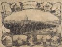
| Description: | Bird's-eye view of Madison, with 12 vignettes and in the center is "The Capitol of Wisconsin View from the Capitol House". The buildings on the top are, fr... |

| Date: | 1871 |
|---|---|
| Description: | Birds eye map of Monroe, WI, depicts street names and street locations, houses, and trees. A reference key at the bottom of the map shows the locations of ... |

| Date: | 1871 |
|---|---|
| Description: | Birds eye map of New London depicts street names and street locations, houses, trees, the bridge, Wolf River, and the bayou. At the bottom of the map, a re... |

| Date: | 1870 |
|---|---|
| Description: | Birds-eye drawing of Oconomowoc depicts street names and street layouts, houses, trees, Oconomowoc River, Fowler Lake, and La Belle Lake. A reference key a... |

| Date: | 1875 |
|---|---|
| Description: | Bird's-eye map of Platteville. |

| Date: | 1892 |
|---|---|
| Description: | Bird's-eye map of Princeton, with an inset of the Residence of F.T. Yahr. Fox River loops to left of center, with one bridge; thirty-six businesses, reside... |

| Date: | 1875 |
|---|---|
| Description: | Bird's-eye map after a fire destroyed a large area of the town. In memory of the Great Conflagration on April 28th, 1875. Taken from the North-Side. |

| Date: | 1883 |
|---|---|
| Description: | Bird's-eye map of Prairie du Sac, Wisconsin with an inset of Clifton. |

| Date: | 1874 |
|---|---|
| Description: | Bird's-eye map of Racine, with an inset of Racine College. |

| Date: | 1875 |
|---|---|
| Description: | Bird's-eye map of Richland Center. |

| Date: | 1891 |
|---|---|
| Description: | Bird's-eye map of Stevens Point, looking east, with an inset of the Water Works. Wisconsin River in foreground with fifty-three business locations identifi... |

| Date: | 1879 |
|---|---|
| Description: | Bird's-eye map of Two Rivers. |

| Date: | 1879 |
|---|---|
| Description: | Bird's-eye view of Viroqua, county seat of Vernon County. |

| Date: | 1896 |
|---|---|
| Description: | Bird's-eye view of Washburn, with twenty vignettes around side, water in foreground with docks and lumber corral. Thirty-three locations identified in key ... |

| Date: | 1910 |
|---|---|
| Description: | Bird's-eye view looking east, with Washburn Harbor at center and Chequamegon Bay in Lake Superior covering most of the upper image. Streets with buildings... |
If you didn't find the material you searched for, our Library Reference Staff can help.
Call our reference desk at 608-264-6535 or email us at:

