 Filter: Categories of Wisconsin Historical Images
Filter: Subject of Church buildings
Filter: Subject of botany
Filter: Categories of Wisconsin Historical Images
Filter: Subject of Church buildings
Filter: Subject of botany
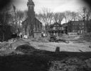
| Date: | 03 03 1926 |
|---|---|
| Description: | Orpheum Theater under construction, 216 State Street, looking west. Also shows Holy Redeemer Catholic Church, 128 W. Johnson Street, Holy Redeemer Rectory,... |
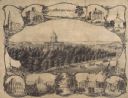
| Date: | 1864 |
|---|---|
| Description: | Bird's-eye view of Madison, with 12 vignettes and in the center is "The Capitol of Wisconsin View from the Capitol House". The buildings on the top are, fr... |

| Date: | 1871 |
|---|---|
| Description: | Birds eye map of Monroe, WI, depicts street names and street locations, houses, and trees. A reference key at the bottom of the map shows the locations of ... |

| Date: | 1871 |
|---|---|
| Description: | Birds eye map of New London depicts street names and street locations, houses, trees, the bridge, Wolf River, and the bayou. At the bottom of the map, a re... |

| Date: | 1870 |
|---|---|
| Description: | Birds-eye drawing of Oconomowoc depicts street names and street layouts, houses, trees, Oconomowoc River, Fowler Lake, and La Belle Lake. A reference key a... |

| Date: | 1875 |
|---|---|
| Description: | Bird's-eye map of Platteville. |

| Date: | 1892 |
|---|---|
| Description: | Bird's-eye map of Princeton, with an inset of the Residence of F.T. Yahr. Fox River loops to left of center, with one bridge; thirty-six businesses, reside... |

| Date: | 1875 |
|---|---|
| Description: | Bird's-eye map after a fire destroyed a large area of the town. In memory of the Great Conflagration on April 28th, 1875. Taken from the North-Side. |

| Date: | 1883 |
|---|---|
| Description: | Bird's-eye map of Prairie du Sac, Wisconsin with an inset of Clifton. |

| Date: | 1874 |
|---|---|
| Description: | Bird's-eye map of Racine, with an inset of Racine College. |

| Date: | 1875 |
|---|---|
| Description: | Bird's-eye map of Richland Center. |

| Date: | 1879 |
|---|---|
| Description: | Bird's-eye map of Two Rivers. |

| Date: | 1879 |
|---|---|
| Description: | Bird's-eye view of Viroqua, county seat of Vernon County. |

| Date: | 1874 |
|---|---|
| Description: | Bird's-eye view of Waukesha, looking southwest, with insets of State Industrial School, Court House, and Fountain Spring House. |

| Date: | 1879 |
|---|---|
| Description: | This map is a bird's-eye view of Wausau, the County Seat of Marathon County. The map features an index of points of interest. |
If you didn't find the material you searched for, our Library Reference Staff can help.
Call our reference desk at 608-264-6535 or email us at:


