 Filter: Categories of Wisconsin Historical Images
Filter: Subject of Church buildings
Filter: Subject of bays
Filter: Categories of Wisconsin Historical Images
Filter: Subject of Church buildings
Filter: Subject of bays
| Date: | 1906 |
|---|---|
| Description: | View of Madison from Lake Monona with the Wisconsin State Capitol building in the background. This view of Brittingham Park shows a part of the park shortl... |
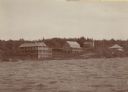
| Date: | 1905 |
|---|---|
| Description: | View across water towards Old Mission, as seen from the pier with Old Mission Congregational Church behind it. This Mission was established in 1830 by Fred... |
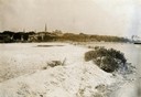
| Date: | |
|---|---|
| Description: | Elevated view looking down on the town with the bay and opposite shoreline in distance. |

| Date: | 1957 |
|---|---|
| Description: | Large Letter style postcard for Green Bay depicting various scenes in the letters that spell the name of the city. Caption reads: "Greetings from Green Bay... |

| Date: | 1914 |
|---|---|
| Description: | Includes index of University of Wisconsin buildings, churches, and public buildings. Top of Map reads: '"GET A SQUARE DEAL" AT THE COLLEGE BOOK STORE SHOWN... |

| Date: | 1900 |
|---|---|
| Description: | This map is shows land in white and water in blue and is indexed for parks, points of interest, schools, churches, and recreational areas. The map shows lo... |

| Date: | 1963 |
|---|---|
| Description: | This blue line print shows as of March 1960 federal, state, county, and town roads, as well as railroads, schools, churches, town hall, parks, and Brown Co... |

| Date: | 1915 |
|---|---|
| Description: | This map shows school houses, churches, farms, and railroads. Chequamecon Bay and Bad River Indian Reservation are labeld. The map reads: "All lands shown ... |

| Date: | 1909 |
|---|---|
| Description: | This map shows vacant Wisconsin Central Ry. lands, settlers houses, lands sold by Wisconsin Central Ry., schools, churches, saw mills, and roads; also show... |
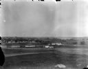
| Date: | |
|---|---|
| Description: | View from University Heights looking south across open fields towards barns and fences. (written on envelope: Camp Randall, Old Dane Country Fair Grounds).... |
| Date: | 1915 |
|---|---|
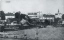
| Description: | View of Ephraim from the bay, with a pier in the foreground. Churches are on the left and right, and the Hillside Hotel is in the center near the shore. Ca... |
| Date: | 1935 |
|---|---|
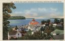
| Description: | Hand-colored elevated view from hill of Ephraim, Eagle Bay and Peninsula State Park. Dwellings and a church are in the foreground. Caption reads: "Ephraim,... |
| Date: | |
|---|---|
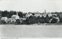
| Description: | Black and white photographic postcard view of Ephraim from Eagle Bay. Churches and dwellings are on the hill above the shoreline. Caption reads: "Greetings... |

| Date: | |
|---|---|
| Description: | View of Ephraim from Eagle Bay. Caption reads: "Ephraim, Door County." Text on reverse reads: "Ephraim is a charming town on Door County's western shorelin... |
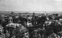
| Date: | |
|---|---|
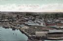
| Description: | Bird's-eye view of Green Bay from the waterfront, with commercial buildings and factories. Caption reads: "Bird's Eye View, Green Bay, Wis." |

| Date: | 1940 |
|---|---|
| Description: | A split rail fence in the foreground frames a view of Eagle Harbor and Ephraim from Peninsula State Park. |
If you didn't find the material you searched for, our Library Reference Staff can help.
Call our reference desk at 608-264-6535 or email us at: