 Filter: Categories of Wisconsin Historical Images
Filter: Subject of Church buildings
Filter: County of Grant
Filter: Year of 1800-1899
Filter: Categories of Wisconsin Historical Images
Filter: Subject of Church buildings
Filter: County of Grant
Filter: Year of 1800-1899

| Date: | 1869 |
|---|---|
| Description: | Birds-eye drawing of Boscobel, Grant County, depicts street names and street layouts, houses, rivers and trees. A reference key at the bottom of the map sh... |

| Date: | 1875 |
|---|---|
| Description: | Bird's-eye map of Platteville. |
| Date: | 1873 |
|---|---|
| Description: | View of Bloomington by the pioneer photographer of the village, Frank Witcomb, sometime after 1873. There are buildings identified in the foreground on bot... |
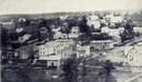
| Date: | 1865 |
|---|---|
| Description: | Stereograph view looking downhill towards Lancaster, with the Congregational Church to the right. |
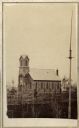
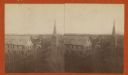
| Date: | 1864 |
|---|---|
| Description: | Slightly elevated view across grounds towards the Trinity Episcopal Church, built in 1864. |

| Date: | 1854 |
|---|---|
| Description: | Pleasant Ridge Log Church. Pleasant Ridge farmers built a United Brethren Church in 1884. |
If you didn't find the material you searched for, our Library Reference Staff can help.
Call our reference desk at 608-264-6535 or email us at: