Filter: Categories of Wisconsin Historical Images
Filter: Subject of Church buildings
Filter: Community of Milwaukee
Filter: Categories of Wisconsin Historical Images
Filter: Subject of Church buildings
Filter: Community of Milwaukee

| Date: | |
|---|---|
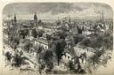
| Description: | Elevated stereograph looking over the city of Milwaukee. In the background is a church, and factory buildings with smoke flowing out of the chimneys. |
| Date: | 1898 |
|---|---|
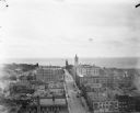
| Description: | Elevated view from the top of the Pabst Building down East Wisconsin Avenue all the way to Milwaukee Bay and out to the horizon of Lake Michigan. One of th... |

| Date: | 1936 |
|---|---|
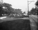
| Description: | View down street of St. Josephat's Basilica and the surrounding streets. |

| Date: | |
|---|---|
| Description: | Stereograph of southwest facade on Martin Street. Built circa 1872. Architect was E.T. Mix. Dirt road in front, and the tower of the Immanuel Church is in... |

| Date: | |
|---|---|
| Description: | Elevated stereograph looking over the city of Milwaukee. In the background is a church, and factory buildings with smoke flowing out of the chimneys. |

| Date: | 1874 |
|---|---|
| Description: | Stereograph of elevated view looking northwest from Exposition Building. There is a church on a street corner on the left, and the Best Brewing Company in ... |
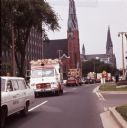
| Date: | 06 1963 |
|---|---|
| Description: | A Sauk County traffic police vehicle leads a line of circus wagons through past two church buildings during a parade originating at Circus World Museum in ... |
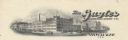
| Date: | |
|---|---|
| Description: | Letterhead of the Gugler Lithographic Company of Milwaukee, Wisconsin, with a three-quarter view of the company building. |
| Date: | 09 1900 |
|---|---|
| Description: | View down Grand Avenue. Near a streetcar is the city's Civil War memorial, erected in 1898 by John Conway. |

| Date: | |
|---|---|
| Description: | Stereograph elevated view of Saint John's Cathedral, on 812 North Jackson Street, from the Courthouse. Lake Michigan is in the background. |

| Date: | |
|---|---|
| Description: | Stereograph view of the interior of the Saint Paul's Church. Features wooden pews, an organ, a large mural over the altar, and columns. Text at right: "Mil... |

| Date: | |
|---|---|
| Description: | The stained-glass windows of Saint Paul's Church. Text at right: "Milwaukee and Vicinity, Photographed by H.H. Bennett." |

| Date: | |
|---|---|
| Description: | Elevated stereograph of the Trinity Church, surrounded by the rooftops of nearby homes. Text at right: "Milwaukee and Vicinity, Photographed by H.H. Bennet... |

| Date: | 1858 |
|---|---|
| Description: | An ink on paper map of Milwaukee County and the eastern portion of Waukesha County that shows the townships of Oak Creek, Franklin, Greenfield, Wauwatosa, ... |

| Date: | 1886 |
|---|---|
| Description: | A hand-colored map of Milwaukee County, Wisconsin that shows the township and range system, sections, towns, roads, railroads and rail stations, cities and... |

| Date: | 1891 |
|---|---|
| Description: | A hand-colored map of Milwaukee County, Wisconsin that shows the township and range system, sections, towns, roads, railroads and rail stations, cities and... |

| Date: | 1902 |
|---|---|
| Description: | A map of Milwaukee County, Wisconsin that shows the township and range system, sections, towns, roads, railroads and rail stations, cities and villages, po... |

| Date: | 1863 |
|---|---|
| Description: | Includes index to public buildings, churches, schools. Inset: Glidden & Lockwood’s addition. Gives names of some property owners. |

| Date: | 05 1958 |
|---|---|
| Description: | Photocopy of a map created by the City of Milwaukee Master Plan Program City Planning Division in May of 1958 representing 1870 "THE CENTRAL AREA OF THE CI... |
If you didn't find the material you searched for, our Library Reference Staff can help.
Call our reference desk at 608-264-6535 or email us at: