 Filter: Categories of Wisconsin Historical Images
Filter: Subject of Children and adults
Filter: Subject of mountains
Filter: Categories of Wisconsin Historical Images
Filter: Subject of Children and adults
Filter: Subject of mountains
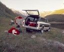
| Date: | 1977 |
|---|---|
| Description: | Color advertising photograph of a family setting up a tent in mountain field near a small lake. An International Traveler pickup with simulated vinyl roof,... |

| Date: | 1915 |
|---|---|
| Description: | Harvesting scene with groups of men, women, and boys and multiple reapers hitched to oxen. Foothills or mountains are in the background, behind a row of t... |
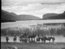
| Date: | 1909 |
|---|---|
| Description: | Children standing on horses' backs posing for the photograph, alongside of a wagon, and other horseback riders, on the shore of Vaseaux Lake. Caption reads... |
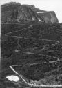
| Date: | |
|---|---|
| Description: | Elevated view of a donkey train going up a zig-zag trail along the mountainside in Glacier National Park. |

| Date: | |
|---|---|
| Description: | View of First Avenue, the main street in town. Stores, restaurants, and lodging houses stand on either side of the street. Snow-covered mountains rise in t... |
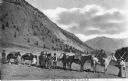
| Date: | |
|---|---|
| Description: | View of a family posed before a pack train, heading toward the mines. |

| Date: | 1973 |
|---|---|
| Description: | View towards lake and mountain with an International Scout hauling a camper parked next to the shoreline. A man, woman, and three children are gathered beh... |

| Date: | |
|---|---|
| Description: | Color reproduction of a painting of a river in the mountains. Two people are standing near the river. Caption reads: "Greetings from Burlington, Wis. A Sum... |

| Date: | 1910 |
|---|---|
| Description: | View of Table Mountain and beach from Milnerton, South Africa. People are walking on the beach. |

| Date: | 1910 |
|---|---|
| Description: | City Hall in Cape Town, South Africa. In the background are mountains. |

| Date: | 1630 |
|---|---|
| Description: | One of the few maps by Dutch cartographer Willem Blaeu depicting the Americas, this map shows regions, settlements, islands, mountains, forests, rivers, an... |

| Date: | 1719 |
|---|---|
| Description: | Map of North America showing land divisions between France, Spain, England, Sweden, Denmark and Holland. The map is detailed, labeling cities, forts, islan... |

| Date: | 1733 |
|---|---|
| Description: | This map of North America shows settlements, rivers, lakes, Native American land, trade winds, and numerous topographical features such as forests and moun... |
If you didn't find the material you searched for, our Library Reference Staff can help.
Call our reference desk at 608-264-6535 or email us at: