 Filter: Categories of Wisconsin Historical Images
Filter: Subject of Children and adults
Filter: Subject of islands
Filter: Categories of Wisconsin Historical Images
Filter: Subject of Children and adults
Filter: Subject of islands

| Date: | |
|---|---|
| Description: | A family kayaks in front of rock walls at the Apostle Islands. |
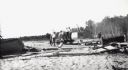
| Date: | 08 29 1922 |
|---|---|
| Description: | Men and boys are on a hand-pump rail cart on a Michigan Island beach, Lake Superior. A young girl is walking on the right. |
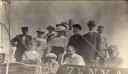
| Date: | 1917 |
|---|---|
| Description: | Group of people on boat "Zenya" at Hermit Island boat landing. L. to r. in back: Captain Angus; Mrs. Stickae; Florence Baker; Mrs. Baker; Elizabeth Abern... |
| Date: | 1914 |
|---|---|
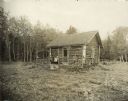
| Description: | Log cabin known as the "haunted house" on Rock Island, remodeled by Chester Thordarson. There are three people sitting on the porch. |
| Date: | |
|---|---|
| Description: | Tents line a beach along the Atlantic Ocean. Foliage covers the foreground and several people and vehicles can be seen throughout the camp. |
| Date: | 1888 |
|---|---|
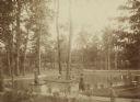
| Description: | Several adults, two children and a dog enjoying a pond at Bracken Brae, the country home of John Johnston (1836-1904), a successful Milwaukee banker. Hilda... |
| Date: | 06 17 1900 |
|---|---|
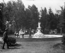
| Description: | Children and adults standing near a figural fountain on Concordia, later Tovoli, Island. |
| Date: | 1915 |
|---|---|
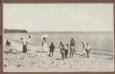
| Description: | A group of children and adults enjoy a sunny day at the beach. Those identified include Mrs. Ferdinand (Clothilde Schmidt) Hotz, on left with hat and light... |

| Date: | 1630 |
|---|---|
| Description: | One of the few maps by Dutch cartographer Willem Blaeu depicting the Americas, this map shows regions, settlements, islands, mountains, forests, rivers, an... |

| Date: | 1683 |
|---|---|
| Description: | Map of the north east coast of North America showing islands, regions, Native American land, bays, and a few European settlements. The Great Lakes appear i... |

| Date: | 1719 |
|---|---|
| Description: | Map of North America showing land divisions between France, Spain, England, Sweden, Denmark and Holland. The map is detailed, labeling cities, forts, islan... |

| Date: | 1733 |
|---|---|
| Description: | This map of North America shows settlements, rivers, lakes, Native American land, trade winds, and numerous topographical features such as forests and moun... |

| Date: | |
|---|---|
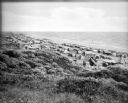
| Description: | A bathing beach on an island near a bridge, with people in the water and on the beach within an enclosed area. A canoe and rowboat are pulled up on the sho... |

| Date: | |
|---|---|
| Description: | Text on reverse reads: "Chateau Madeleine La Pointe, Wisconsin Summer and Fall Resort on Madeline Island (Apostle Islands) in Lake Superior. The Chateau's... |
If you didn't find the material you searched for, our Library Reference Staff can help.
Call our reference desk at 608-264-6535 or email us at: