 Filter: Categories of Wisconsin Historical Images
Filter: Subject of Cemeteries
Filter: Categories of Wisconsin Historical Images
Filter: Subject of Cemeteries
| Date: | 1933 |
|---|---|
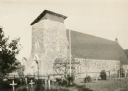
| Description: | The Catholic church of St. Francis Solanus is located on the Lac Courte Oreilles reservation. The church was built 1923-1924 of native pipestone under the ... |
| Date: | |
|---|---|
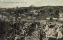
| Description: | Partially colorized view looking down at a quarry. On the other side of the quarry is the town of Berlin, with dwellings and commercial buildings. Caption ... |
| Date: | |
|---|---|
| Description: | If everything stopped dead — watches, tickers, hands — on every island something new would bloom and another age begin |

| Date: | |
|---|---|
| Description: | New land cut out by real imaginary lines based in older spirit courses lay and bedrock, flight of birds and pointed feet |
| Date: | 11 12 1980 |
|---|---|
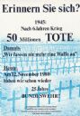
| Description: | German poster protesting the ongoing presence of the Bundeswehr, the West German armed forces. Poster shows a screenprinted image in blue of rows of cros... |
| Date: | |
|---|---|
| Description: | The monument is now The place is ripe for building a roll-call of seekers out of the earth For each, his glory is the doing and his dre... |
| Date: | |
|---|---|
| Description: | His mind wandered without rescue The man is innocent. and had to be brought home to the corner and stapled to the ground |
| Date: | |
|---|---|
| Description: | Although they remembered everything that could not be tolerated, their better natures, surfacing through waves of church-worn care, prevailed over... |

| Date: | 1890 |
|---|---|
| Description: | Large group, posed at a distance, in a cemetery, probably in Hixton or Schlecterville. |
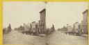
| Date: | 1870 |
|---|---|
| Description: | Stereograph view of Oconomowoc. |

| Date: | 1961 |
|---|---|
| Description: | Country cemetery among tall, dark evergreen trees. |

| Date: | 1939 |
|---|---|
| Description: | This is a zoning map of Wauwatosa with a key of districts including agricultural, resident, business, commercial, and industrial. The map features labeled ... |

| Date: | 1947 |
|---|---|
| Description: | This map of Ashland is a cadastral map showing some rural landowners and includes index to points of interest. The map shows roads, railroads, parks, cemet... |

| Date: | 1961 |
|---|---|
| Description: | Vista over farmland from a small country cemetery. |
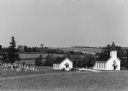
| Date: | 09 1986 |
|---|---|
| Description: | Zion Church on Zion Church Road. |

| Date: | 05 1989 |
|---|---|
| Description: | Legionaries place flowers on graves at River Church Cemetery. |

| Date: | 1880 |
|---|---|
| Description: | This map of La Crosse shows the Chicago, Milwaukee and St. Paul Railroad, the Southern Minnesota Railroad and the Chicago, Dubuque and Minnesota Railroad, ... |

| Date: | 1891 |
|---|---|
| Description: | This map of La Crosse shows eighteen city wards in red, railroads, cemeteries, fair grounds, labeled streets, islands, and the Mississippi River. The left ... |

| Date: | 1893 |
|---|---|
| Description: | This map of La Crosse shows city ward boundaries in red, streets, railroads, cemeteries, Grand station crossing, the road to French Island, depots, Lake Pa... |

| Date: | 1900 |
|---|---|
| Description: | This map of La Crosse shows twenty wards, some rural lots with acreages, streets, railroads, depots, bridges, cemeteries, parks, schools, islands, and the ... |
If you didn't find the material you searched for, our Library Reference Staff can help.
Call our reference desk at 608-264-6535 or email us at: