 Filter: Categories of Wisconsin Historical Images
Filter: Subject of Cemeteries
Filter: Year of 1800-1899
Filter: Year of 1890-1899
Filter: Categories of Wisconsin Historical Images
Filter: Subject of Cemeteries
Filter: Year of 1800-1899
Filter: Year of 1890-1899
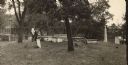
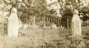
| Date: | 1890 |
|---|---|
| Description: | People in a cemetery. Includes a view of the Scofield family monument. |
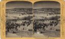
| Date: | 05 1895 |
|---|---|
| Description: | Albumen print of spectators standing and seated around the public receiving tomb in Oakridge Cemetery where Abraham Lincoln's body was placed after his fun... |
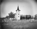
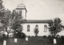
| Date: | 1890 |
|---|---|
| Description: | Little Norway Church, with graveyard, located south of Black River Falls. |
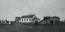
| Date: | 1890 |
|---|---|
| Description: | German Methodist Episcopal Church with a cemetery. The congregation was organized in 1859 and the church was put up in the early 1860's. The church is no l... |
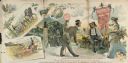
| Date: | 1890 |
|---|---|
| Description: | Advertising poster for Champion brand agricultural machines, manufactured by Warder, Bushnell and Glessner Company. The main illustration depicts a salesma... |
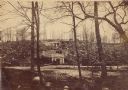
| Date: | 1895 |
|---|---|
| Description: | Fort Crawford Military Cemetery. Photograph made before restoration by the United States Government. Soldiers' families were also buried in the cemetery. |
| Date: | 1895 |
|---|---|
| Description: | Fort Crawford Military Cemetery, as seen before it was restored by the United States Government. Two people are standing in the center near the tombs. |
| Date: | 1898 |
|---|---|
| Description: | Exterior view of Zwingli Reformed Church and cemetery. |
| Date: | 1898 |
|---|---|
| Description: | View through the closed gate, which has a sign that reads: Old Fort Winnebago Cemetery. Overgrown plants surround the gate, and trees surround a monument j... |

| Date: | 1898 |
|---|---|
| Description: | "Confederate Rest" in Forest Hill Cemetery where Confederate prisoners of war who died at Camp Randall are buried. In this early photograph, there is a woo... |
| Date: | 1893 |
|---|---|
| Description: | A replication of the crucifixion of Jesus Christ. Depicted is the garden of Joseph of Arimathea and the tomb where Jesus is believed to be the buried. A Ro... |

| Date: | 1896 |
|---|---|
| Description: | A hand-colored Map of Jefferson County, Wisconsin, shows township and section divisions, towns, villages and post offices, rural residents, railroads, road... |

| Date: | 1896 |
|---|---|
| Description: | This 1896 map of Racine and Kenosha counties, Wisconsin, shows the township and range grid, towns, sections, cities, villages and post offices, roads, rail... |

| Date: | 1896 |
|---|---|
| Description: | This late 19th century map of Walworth County, Wisconsin, shows the township and range grid, towns, sections, villages and post offices, roads, railroads, ... |

| Date: | 1899 |
|---|---|
| Description: | This 1899 map of Dodge County, Wisconsin, shows the township and range grid, towns, sections, cities and villages, roads, railroads, post offices, cemeteri... |

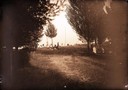
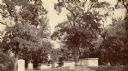
| Date: | 1890 |
|---|---|
| Description: | Large group, posed at a distance, in a cemetery, probably in Hixton or Schlecterville. |

| Date: | 1891 |
|---|---|
| Description: | This map of La Crosse shows eighteen city wards in red, railroads, cemeteries, fair grounds, labeled streets, islands, and the Mississippi River. The left ... |

| Date: | 1893 |
|---|---|
| Description: | This map of La Crosse shows city ward boundaries in red, streets, railroads, cemeteries, Grand station crossing, the road to French Island, depots, Lake Pa... |

| Date: | 1890 |
|---|---|
| Description: | This map shows lot and block numbers and dimensions, landownership, city wards, buildings, streets, railroads, parks, cemeteries, churches, schools, and in... |

| Date: | 1891 |
|---|---|
| Description: | This hand-colored map shows platted additions and subdivisions, ward boundaries, schools, churches, railroads, cemeteries, parks, businesses, factories, an... |
If you didn't find the material you searched for, our Library Reference Staff can help.
Call our reference desk at 608-264-6535 or email us at: