 Filter: Categories of Wisconsin Historical Images
Filter: Subject of Cemeteries
Filter: Year of 1800-1899
Filter: Year of 1870-1879
Filter: Categories of Wisconsin Historical Images
Filter: Subject of Cemeteries
Filter: Year of 1800-1899
Filter: Year of 1870-1879
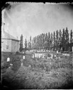
| Date: | 1874 |
|---|---|
| Description: | View of the East Koshkonong Church, a stone church built in 1858 and rebuilt in 1893. One grave marking and a stone fence are in the foreground. A brick wa... |
| Date: | 1873 |
|---|---|
| Description: | Women with parasols in Oak Hill Cemetery. Thomas and Hannah Robinson's tombstones can be seen. |
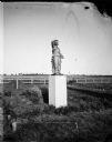
| Date: | 1879 |
|---|---|
| Description: | One of the eight female figures purchased from the Chicago firm Gould Brothers and Dribblee to be used on the gate posts of the Wisconsin State Capitol fen... |
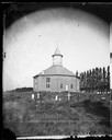
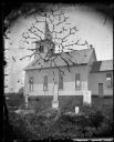
| Date: | 1878 |
|---|---|
| Description: | West Koshkonong Lutheran Church and cemetery. Octagonal stone church built in 1852, rebuilt in 1893, seating 800 people. |
| Date: | 1878 |
|---|---|
| Description: | West Koshkonong Lutheran Church, an octagonal stone church built in 1852 and cemetery. The headstone of Cecilia Martins Datter is legible. Further refere... |
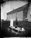
| Date: | 1873 |
|---|---|
| Description: | Norwegian-American farm laborer, Hans Christianson (age 44), stands next to the grave of his childless wife, Karen Luis Christianson, born 1829, who died J... |

| Date: | 1872 |
|---|---|
| Description: | View of the Spring Prairie Lutheran Church, built in 1853 and replaced in 1886. |
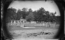
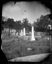
| Date: | 1872 |
|---|---|
| Description: | Two woman sitting in Oak Hill Cemetery. Board fencing, with a set of steps near the gate, surrounds the graveyard. Picket fences set off some of the headst... |
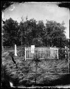
| Date: | 1876 |
|---|---|
| Description: | The Old York Cemetery. The 1872 headstone of Haldor, son of Syver and Martha Holland, is in the foreground, surrounded by a picket fence. |
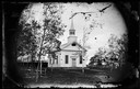
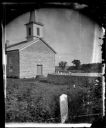
| Date: | 1870 |
|---|---|
| Description: | View of the front of the Union Congregational Church, a Greek Revival structure, built in 1862. A carriage shed and cemetery are adjacent to the church. |
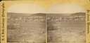
| Date: | 1876 |
|---|---|
| Description: | A view of the town of Lodi as viewed from the hill north of the cemetery. |
| Date: | 1876 |
|---|---|
| Description: | East Blue Mounds Lutheran Church, formerly Norsk Evangelisk Kirke, built in 1868. The graves of Andreas L. Dahl's mother, Berthe Nelsdatter (Lund) Dahlen, ... |

| Date: | 1870 |
|---|---|
| Description: | View toward the tombstones and a building at Hillside Cemetery and Park. In the foreground is a pond surrounded by vegetation. |

| Date: | 1870 |
|---|---|
| Description: | A map of Iowa County, Wisconsin mounted on cloth that shows the villages of Avoca, Mifflin, Linden, Arena, Helena Station, Highland, Dodgeville, as well as... |

| Date: | 1876 |
|---|---|
| Description: | This 1876 map of Saint Croix County, Wisconsin, shows the township and range grid, sections, towns, cities and villages, land ownership and acreages, wagon... |

| Date: | 1877 |
|---|---|
| Description: | This 1877 map of Sauk County, Wisconsin, shows the township and range grid, sections, towns, cities and villages, land ownership and acreages, wagon roads,... |

| Date: | 1878 |
|---|---|
| Description: | This 1878 map of Vernon County, Wisconsin, shows the township and range grid, sections, towns, cities and villages, land ownership and acreages, roads, rai... |

| Date: | 1878 |
|---|---|
| Description: | This map of Crawford County, Wisconsin, shows the township and range grid, sections, towns, cities and villages, land ownership and acreages, roads, railro... |

| Date: | 1873 |
|---|---|
| Description: | This 1874 map of Washington and Ozaukee counties, Wisconsin, shows the township and range grid, towns, sections, cities and villages, rural landownership a... |

| Date: | 1874 |
|---|---|
| Description: | This 1873 map covers the northern halves (Towns 11 and 12) of Washington and Ozaukee counties. Shown are the township and range grid, towns, sections, citi... |
If you didn't find the material you searched for, our Library Reference Staff can help.
Call our reference desk at 608-264-6535 or email us at: