 Filter: Categories of Wisconsin Historical Images
Filter: Subject of Cemeteries
Filter: Year of 1800-1899
Filter: Year of 1850-1859
Filter: Categories of Wisconsin Historical Images
Filter: Subject of Cemeteries
Filter: Year of 1800-1899
Filter: Year of 1850-1859
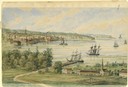
| Date: | 1858 |
|---|---|
| Description: | View from the second story of the Salesianum, the residence of Dr. Salzmann. The view includes Lake Michigan, the Milwaukee shoreline, and some of the nume... |

| Date: | 1858 |
|---|---|
| Description: | This 1858 map of Racine County, Wisconsin, shows land ownership and acreages, the township and range grid, towns, cities and villages, roads, railroads, sc... |

| Date: | 1857 |
|---|---|
| Description: | This map shows section corners, quarter section corners, foundry, steam saw mill, steam grist mill, planning mill, court house, baptist church, congregatio... |

| Date: | 1857 |
|---|---|
| Description: | This map shows land ownership by name, local streets, wards, buildings, parks, a cemetery, and part of Lake Michigan. Depths are shown by soundings and nor... |

| Date: | 1856 |
|---|---|
| Description: | This map shows lot and block numbers, streets, the Mississippi River, Fort Crawford, depot ground, and a graveyard. An old fort location is outlined in red... |

| Date: | 1858 |
|---|---|
| Description: | This map shows lot and block numbers, landownership, buildings, railroads, roads, wards, points of interest, parks, and cemeteries. Also included are illus... |

| Date: | 1858 |
|---|---|
| Description: | This map shows city wards, streets, block and lot numbers, cemeteries, buildings, landownership, forests, railroads, a race course, quarries, and orchards.... |

| Date: | 1857 |
|---|---|
| Description: | This map shows lot and block numbers, buildings, some land ownership, wards, waterways, streets, railroads, brick yards, and cemeteries. It includes an ind... |

| Date: | 1856 |
|---|---|
| Description: | This map shows the city as planned by the General Colonization Society, including streets, land parcels, two subdivisions of out-lots with graveyard, schoo... |
If you didn't find the material you searched for, our Library Reference Staff can help.
Call our reference desk at 608-264-6535 or email us at: