 Filter: Categories of Wisconsin Historical Images
Filter: Subject of Cemeteries
Filter: Subject of transportation
Filter: Categories of Wisconsin Historical Images
Filter: Subject of Cemeteries
Filter: Subject of transportation

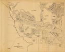
| Date: | 1891 |
|---|---|
| Description: | This hand-colored map shows platted additions and subdivisions, ward boundaries, schools, churches, railroads, cemeteries, parks, businesses, factories, an... |

| Date: | 1956 |
|---|---|
| Description: | This map shows local streets, roads, railroads, highways, parks, cemeteries, hospitals, the University of Wisconsin, Middleton, Maple Bluff, Shorewood Hill... |

| Date: | 1966 |
|---|---|
| Description: | This map shows streets, highways, railroads, parks, colleges, cemeteries, county clubs, University of Wisconsin, Truax Field, Middleton, Shorewood Hills, M... |

| Date: | 1971 |
|---|---|
| Description: | This map shows streets, highways, railroads, parks, colleges, cemeteries, county clubs, University of Wisconsin, Truax Field, Middleton, Shorewood Hills, M... |

| Date: | |
|---|---|
| Description: | This plat map shows numbered blocks and lots, wards, local streets, railroads, cemeteries, buildings, land ownership by name, and parts of Manitowoc River ... |
| Date: | |
|---|---|
| Description: | This map is a photocopy and shows the Oconomowoc River, Flower Lake, lot and block numbers and dimensions, additions, streets, C.M.St.P.&P. Ry., T.M.E.R.&L... |

| Date: | 1858 |
|---|---|
| Description: | This map shows city wards, streets, block and lot numbers, cemeteries, buildings, landownership, forests, railroads, a race course, quarries, and orchards.... |

| Date: | 1892 |
|---|---|
| Description: | This map shows water pipes, hydrants, stop cocks, check valves, fire cysterns, and manholes. Also shown are block numbers, streets, railroads, parks, cemet... |

| Date: | 1892 |
|---|---|
| Description: | This map shows schools, engine houses, railroads, street railways, wards, parks, cemeteries, block numbers, a street index, explanations, and general refer... |

| Date: | 1893 |
|---|---|
| Description: | This map shows city wards, block numbers, parks, cemeteries, roads, railroads, selected buildings, and Lake Michigan. Also included are indexes to streets,... |

| Date: | 1897 |
|---|---|
| Description: | This map shows city wards, block numbers, parks, cemeteries, roads, railroads, Lake Michigan, and selected buildings. Also included are indexes to streets,... |

| Date: | 1898 |
|---|---|
| Description: | This map shows city wards, block numbers, parks, cemeteries, roads, railroads, Lake Michigan, and selected buildings. Also included are indexes "Milwaukee ... |

| Date: | 1900 |
|---|---|
| Description: | This map shows city wards, block numbers, parks, cemeteries, roads, railroads, Lake Michigan, and selected buildings. Also included are indexes "Milwaukee ... |

| Date: | 1970 |
|---|---|
| Description: | This map shows lots, house numbers, institutional buildings, and cemeteries. The bottom of the map includes indexes to streets, points of interest and inst... |

| Date: | 1901 |
|---|---|
| Description: | This map shows city wards, block numbers, parks, cemeteries, roads, railroads, Lake Michigan, and selected buildings. Also included are indexes "Milwaukee ... |

| Date: | 1960 |
|---|---|
| Description: | This blue line print shows state and city maintained roads, as well as government land, parks, Milwaukee Co. Park Commission, golf courses, schools, City o... |

| Date: | 1955 |
|---|---|
| Description: | This blue line print shows streets, fair grounds, schools, parks, and a cemetery. Streets, points of interest, and Lake Marinuka are labeled. The middle le... |

| Date: | 1964 |
|---|---|
| Description: | This map shows various zoning sections and includes labeled streets, parks, and cemeteries. The upper left corner contains a legend of land use. |

| Date: | 1965 |
|---|---|
| Description: | This map shows streets, churches, schools, wards, railroads, parks and fields, cemeteries, Historical Museum, Yacht Basin & Marina, and Marinette General H... |

| Date: | 1904 |
|---|---|
| Description: | This map shows wards, schools, engine houses, railroads, street railways, block numbers, parks, roads, and Lake Michigan. Also included are indexes: Table ... |
If you didn't find the material you searched for, our Library Reference Staff can help.
Call our reference desk at 608-264-6535 or email us at: