 Filter: Categories of Wisconsin Historical Images
Filter: Subject of Cemeteries
Filter: Subject of streets
Filter: Categories of Wisconsin Historical Images
Filter: Subject of Cemeteries
Filter: Subject of streets
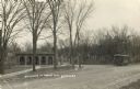
| Date: | 1911 |
|---|---|
| Description: | Entrance to the Forest Hill Cemetery, with a streetcar on the right. |

| Date: | 1881 |
|---|---|
| Description: | Bird's-eye map of Milton Junction. |
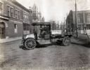
| Date: | 1919 |
|---|---|
| Description: | International model "F" "31" truck operated by Striplins Transfer of Litchfield. A male driver is in the truck which is parked on a city street between a ... |

| Date: | |
|---|---|
| Description: | A stone archway over the entrance of Cypress Hill Cemetery. |

| Date: | 1914 |
|---|---|
| Description: | Plat book of Waukesha County. Pages 14 - 15. |
| Date: | 02 16 1978 |
|---|---|
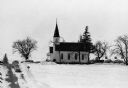
| Description: | "Zion Lutheran Church, Town of Theresa. At this moment, funeral services of Herb Sellnow are taking place." |

| Date: | 1972 |
|---|---|
| Description: | This map on 5 sheets features a title page sheet with business directory and shows section numbers, roads, railroads, saw mills, churches, blacksmith shops... |

| Date: | 1947 |
|---|---|
| Description: | Shows lot and block numbers, 28 points of interest in the upper left that correspond to numbers on the map, and landownership with acreages. "Erickson Brot... |

| Date: | 1840 |
|---|---|
| Description: | Pen-and-ink on paper. Map shows 1840’s homes with owner names, a Native American cemetery, and other points of interest. Relief shown by hachures. Oriented... |

| Date: | 1875 |
|---|---|
| Description: | Shows land ownership by name, local streets, buildings, cemeteries, Chippewa River, and Half Moon Lake. Includes 1 inset map of Eau Claire. Also includes c... |

| Date: | 1911 |
|---|---|
| Description: | View down center of Main Street. On the left is the Hotel Lewis, with a columned porch and awnings above the second-story windows. Further down the street ... |

| Date: | 1976 |
|---|---|
| Description: | Includes index of streets and of local businesses. Shows location of Citizens State Bank, roads, highways, railroads, parks, cemeteries, and city sanitary ... |

| Date: | 1931 |
|---|---|
| Description: | Map shows street map with wards numbered, the Fox River, railroads, playgrounds, cemeteries, and schools. The map also includes a manuscript annotation ind... |

| Date: | 01 1940 |
|---|---|
| Description: | Map shows roads, railroads, the Fox River, parks, schools, and cemeteries and is indexed by street name in the margins. The bottom of the map show the Winn... |

| Date: | 1957 |
|---|---|
| Description: | Map is indexed by street name in the margins. The map shows roads, highways, railroads, parks, city buildings, schools, cemeteries, city limits, and the Fo... |
| Date: | 1943 |
|---|---|
| Description: | Map shows the town of St. Catherine, Wisconsin, between Lake Street and Doty Street as it appeared on January 3, 1852. Map is situated facing north with La... |
| Date: | |
|---|---|
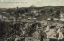
| Description: | Partially colorized view looking down at a quarry. On the other side of the quarry is the town of Berlin, with dwellings and commercial buildings. Caption ... |
| Date: | |
|---|---|
| Description: | His mind wandered without rescue The man is innocent. and had to be brought home to the corner and stapled to the ground |
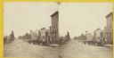
| Date: | 1870 |
|---|---|
| Description: | Stereograph view of Oconomowoc. |

| Date: | 1939 |
|---|---|
| Description: | This is a zoning map of Wauwatosa with a key of districts including agricultural, resident, business, commercial, and industrial. The map features labeled ... |
If you didn't find the material you searched for, our Library Reference Staff can help.
Call our reference desk at 608-264-6535 or email us at: