 Filter: Categories of Wisconsin Historical Images
Filter: Subject of Cemeteries
Filter: Subject of recreation areas
Filter: Subject of rivers
Filter: Categories of Wisconsin Historical Images
Filter: Subject of Cemeteries
Filter: Subject of recreation areas
Filter: Subject of rivers

| Date: | 1947 |
|---|---|
| Description: | Shows lot and block numbers, 28 points of interest in the upper left that correspond to numbers on the map, and landownership with acreages. "Erickson Brot... |

| Date: | 1952 |
|---|---|
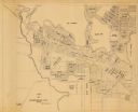
| Description: | Map shows roads, highways, railroads, parks, city buildings, schools, cemeteries, city limits, and the Fox River. The map is indexed by street name, street... |

| Date: | 1931 |
|---|---|
| Description: | Relief shown by contours and spot heights. Maps shows United States, state, county and local highways and roads, schools, North Bend, creeks, lakes, rivers... |

| Date: | 1916 |
|---|---|
| Description: | Map shows roads, railroads, the Fox River, parks, and cemeteries. Wards are numbered and the edges of the map feature coordinates. The top left of the map ... |

| Date: | 1931 |
|---|---|
| Description: | Map shows street map with wards numbered, the Fox River, railroads, playgrounds, cemeteries, and schools. The map also includes a manuscript annotation ind... |

| Date: | 01 1940 |
|---|---|
| Description: | Map shows roads, railroads, the Fox River, parks, schools, and cemeteries and is indexed by street name in the margins. The bottom of the map show the Winn... |

| Date: | 1939 |
|---|---|
| Description: | This is a zoning map of Wauwatosa with a key of districts including agricultural, resident, business, commercial, and industrial. The map features labeled ... |

| Date: | 1936 |
|---|---|
| Description: | Street map of the City of Milwaukee and surrounding suburbs indicating various mass transit lines. There is an index to Milwaukee streets at the right of t... |

| Date: | 1938 |
|---|---|
| Description: | This map shows plat of town, land ownership by name, city limits, section boundaries, wards, local roads, railroads, parks, fairgrounds, cemeteries, locati... |

| Date: | 1918 |
|---|---|
| Description: | This map has relief shown by hachures and is indexed by street name and buildings. The map shows plat of town, city limits, local streets, railroads, schoo... |

| Date: | 1873 |
|---|---|
| Description: | This map shows land ownership by name, local streets, railroads, parks, college grounds, schools, cemeteries, and part of Rock River. The upper left margin... |

| Date: | 1975 |
|---|---|
| Description: | This standard U.S.G.S. topographic map was annotated by civil engineer and railroad historian James P. Kaysen to show the location of existing and defunct ... |

| Date: | 1883 |
|---|---|
| Description: | This map shows ward boundaries, names of additions, streets, bridges, mills, schools, religious buildings, businesses, hotels, railroads, factories, brewer... |

| Date: | 1934 |
|---|---|
| Description: | This map is attached to a cover. Streets, points of interest, the Milwaukee River, and Lake Michigan are labeled. The bottom margin of the map includes a s... |

| Date: | 1858 |
|---|---|
| Description: | This map shows lot and block numbers, landownership, buildings, railroads, roads, wards, points of interest, parks, and cemeteries. Also included are illus... |

| Date: | 01 18 1907 |
|---|---|
| Description: | This map shows Lake Michigan, streets, schools, churches, businesses, cemeteries, parks, and railroads. Relief is shown by contours; depths are shown by so... |

| Date: | 1891 |
|---|---|
| Description: | This hand-colored map shows platted additions and subdivisions, ward boundaries, schools, churches, railroads, cemeteries, parks, businesses, factories, an... |
| Date: | |
|---|---|
| Description: | This map is a photocopy and shows the Oconomowoc River, Flower Lake, lot and block numbers and dimensions, additions, streets, C.M.St.P.&P. Ry., T.M.E.R.&L... |

| Date: | 1892 |
|---|---|
| Description: | This map shows water pipes, hydrants, stop cocks, check valves, fire cysterns, and manholes. Also shown are block numbers, streets, railroads, parks, cemet... |

| Date: | 1892 |
|---|---|
| Description: | This map shows schools, engine houses, railroads, street railways, wards, parks, cemeteries, block numbers, a street index, explanations, and general refer... |
If you didn't find the material you searched for, our Library Reference Staff can help.
Call our reference desk at 608-264-6535 or email us at: