Filter: Categories of Wisconsin Historical Images
Filter: Subject of Cemeteries
Filter: Subject of indians of north america
Filter: Year of 1900-1999
Filter: Categories of Wisconsin Historical Images
Filter: Subject of Cemeteries
Filter: Subject of indians of north america
Filter: Year of 1900-1999
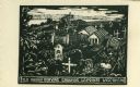
| Date: | 1959 |
|---|---|
| Description: | Caption reads: "Old Indian Burying Grounds LaPointe Wisconsin." |
| Date: | 1918 |
|---|---|
| Description: | Burial grounds in La Pointe. A man is standing in the center with his back turned to the camera. |

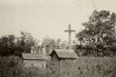
| Date: | 1905 |
|---|---|
| Description: | Indian cemetery. A large body of water is in the background. Caption reads: "Indian Burying Grounds, Bayfield, Wis." |
| Date: | 06 1919 |
|---|---|
| Description: | Ojibwe (Chippewa) Indian cemetery among brush and trees. Probably Lac Courte Oreilles. |
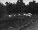
| Date: | 1935 |
|---|---|
| Description: | Ojibwe wooden burial houses surrounded by wooden fence on Madeline Island. Two women stand in the background. |
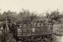
| Date: | 1935 |
|---|---|
| Description: | Wooden burial house, plots and crosses surrounded by wooden fence on Madeline Island. |
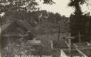
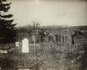
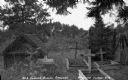
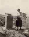
| Date: | 1958 |
|---|---|
| Description: | Local historian William F. Wolf visiting the Native American cemetery. In the background is a barn and a silo and other farm buildings. |

| Date: | 1920 |
|---|---|
| Description: | This map shows the township and range system, sections, schools, churches, cemeteries, town halls, roads, railroads, and lakes and streams in Shawano Count... |
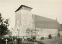
| Date: | 1933 |
|---|---|
| Description: | The Catholic church of St. Francis Solanus is located on the Lac Courte Oreilles reservation. The church was built 1923-1924 of native pipestone under the ... |
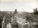
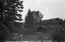
| Date: | 1920 |
|---|---|
| Description: | View of the cemetery at Skunk Hill (Tah-qua-kik). |

| Date: | 1907 |
|---|---|
| Description: | This blueprint map shows a proposed plan for pleasure roads and reservation system. It also shows schools, cemeteries, old river channel, proposed bridge, ... |

| Date: | 07 1936 |
|---|---|
| Description: | Wooden roof-like grave covers and fences mark the graves in a Madeline Island cemetery. There is also a wooden cross on the right. Originally named St. Jo... |
| Date: | 1926 |
|---|---|
| Description: | A woman holding flowers is standing between two graves, looking at the one on the left. Caption reads: "Wind River Indian Reservation (formerly the Shosho... |
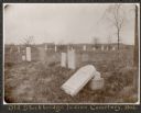
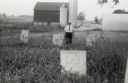
| Date: | 1906 |
|---|---|
| Description: | View of a cemetery with several tombstones, one of which appears broken and resting against its base. A building is in the background. Caption reads: "Th... |
If you didn't find the material you searched for, our Library Reference Staff can help.
Call our reference desk at 608-264-6535 or email us at: