Filter: Categories of Wisconsin Historical Images
Filter: Subject of Cemeteries
Filter: Subject of indians of north america
Filter: Subject of cities and towns
Filter: Categories of Wisconsin Historical Images
Filter: Subject of Cemeteries
Filter: Subject of indians of north america
Filter: Subject of cities and towns
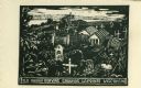
| Date: | 1959 |
|---|---|
| Description: | Caption reads: "Old Indian Burying Grounds LaPointe Wisconsin." |

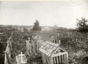
| Date: | 1905 |
|---|---|
| Description: | Indian cemetery. A large body of water is in the background. Caption reads: "Indian Burying Grounds, Bayfield, Wis." |
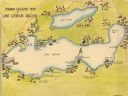
| Date: | |
|---|---|
| Description: | A color, pictorial map that shows sites related to Native American villages, sites, cemeteries in the area around the lakes Geneva and Como in Walworth Cou... |

| Date: | 1920 |
|---|---|
| Description: | This map shows the township and range system, sections, schools, churches, cemeteries, town halls, roads, railroads, and lakes and streams in Shawano Count... |

| Date: | |
|---|---|
| Description: | This map is pen-and-ink on tracing paper with a mounted legend and shows the Kickapoo River, Indian mounds, the 1st Fort Crawford, an Indian Agency, the si... |

| Date: | 1907 |
|---|---|
| Description: | This blueprint map shows a proposed plan for pleasure roads and reservation system. It also shows schools, cemeteries, old river channel, proposed bridge, ... |

| Date: | 1791 |
|---|---|
| Description: | Small map of an abandoned Native American town and fort at the junction of the Ohio and Muskingum River. It shows the fortifications, an outline of the tow... |
If you didn't find the material you searched for, our Library Reference Staff can help.
Call our reference desk at 608-264-6535 or email us at: