 Filter: Categories of Wisconsin Historical Images
Filter: Subject of Cemeteries
Filter: Subject of human settlements
Filter: Subject of transportation
Filter: Categories of Wisconsin Historical Images
Filter: Subject of Cemeteries
Filter: Subject of human settlements
Filter: Subject of transportation
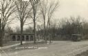
| Date: | 1911 |
|---|---|
| Description: | Entrance to the Forest Hill Cemetery, with a streetcar on the right. |
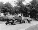
| Date: | 1935 |
|---|---|
| Description: | Workers tending the grounds of the Forest Home Cemetery using a McCormick-Deering I-12 tractor and wagon. |

| Date: | 1923 |
|---|---|
| Description: | Map of Oneida County-Rhinelander Airport which was laid out at the county fairgrounds. The map appears on the reverse side of a letter Roy Larson received ... |

| Date: | 1881 |
|---|---|
| Description: | Bird's-eye map of Milton Junction. |

| Date: | 1910 |
|---|---|
| Description: | An open streetcar labeled Fair Oaks sitting near Forest Hills Cemetery, which was then the end of the line. The motorman has been identified as Jack Schwen... |
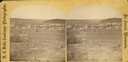
| Date: | 1876 |
|---|---|
| Description: | A view of the town of Lodi as viewed from the hill north of the cemetery. |

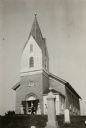
| Date: | 05 10 1928 |
|---|---|
| Description: | The Lutheran Church and buildings, seen from Lutheran Church Hill. |
| Date: | 1921 |
|---|---|
| Description: | View from cemetery towards the front of the Muskego Church. People are standing near the entrance. |

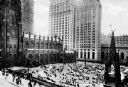
| Date: | 1969 |
|---|---|
| Description: | Cemetery with a view across the street of the World Trade Center construction site. |

| Date: | 02 06 1948 |
|---|---|
| Description: | Aerial photograph of Madison's west side looking northeast along Speedway Road. Visible are Forest Hill and Resurrection Cemeteries, West High School, Hoyt... |

| Date: | 02 06 1948 |
|---|---|
| Description: | Aerial view of west side, looking south along Glenway Street. Visible are the reservoir, Lake Wingra, Forest Hill and Resurrection Cemetery, Hoyt Park. Maj... |

| Date: | 02 06 1948 |
|---|---|
| Description: | Aerial photograph looking northwest across the reservoir on Glenway Street. Featured are Hoyt and Quarry Parks, Resurrection Cemetery. Major streets are Fr... |

| Date: | 02 06 1948 |
|---|---|
| Description: | Looking north along Glenway Street. Visible are the reservoir, Hoyt and Quarry Parks, Resurrection and Forest Hill Cemeteries, Rentschler Greenhouses, Fore... |

| Date: | 02 06 1948 |
|---|---|
| Description: | Looking southeast across Speedway Road. Visible are the reservoir on Glenway Street, Hoyt Park, Resurrection and Forest Hill cemeteries, Glenway Golf cours... |

| Date: | 02 06 1948 |
|---|---|
| Description: | Looking east along Regent Street with snow on the ground. Visible are Lake Wingra, Monona Bay, railroad causeway across Monona, Lake Mendota, Hoyt Park, We... |
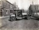
| Date: | 1919 |
|---|---|
| Description: | International model "F" "31" truck operated by Striplins Transfer of Litchfield. A male driver is in the truck which is parked on a city street between a ... |
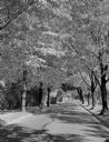
| Date: | 09 30 1949 |
|---|---|
| Description: | Fall scene looking east in the 2600 block of Regent Street along the Catholic cemetery. |
| Date: | |
|---|---|
| Description: | Elevated view of a Gothic revival style Trinity church Wall Street and adjacent cemetery. Modern skyscrapers are in the background. |

| Date: | |
|---|---|
| Description: | A stone archway over the entrance of Cypress Hill Cemetery. |

| Date: | |
|---|---|
| Description: | A view of the church from the side, as well as a view of the grounds, which includes a cemetery. An iron fence surrounds the grounds, with both carriage an... |
If you didn't find the material you searched for, our Library Reference Staff can help.
Call our reference desk at 608-264-6535 or email us at: