 Filter: Categories of Wisconsin Historical Images
Filter: Subject of Cemeteries
Filter: Subject of farm buildings
Filter: Year of 1900-1999
Filter: Categories of Wisconsin Historical Images
Filter: Subject of Cemeteries
Filter: Subject of farm buildings
Filter: Year of 1900-1999

| Date: | 1923 |
|---|---|
| Description: | Map of Oneida County-Rhinelander Airport which was laid out at the county fairgrounds. The map appears on the reverse side of a letter Roy Larson received ... |

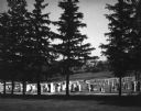
| Date: | 05 10 1928 |
|---|---|
| Description: | The Lutheran Church and buildings, seen from Lutheran Church Hill. |
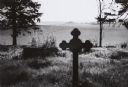
| Date: | 1970 |
|---|---|
| Description: | A country cemetery with a row of pine trees in the foreground. In the far distance is a farm. |
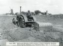
| Date: | 06 1926 |
|---|---|
| Description: | A man uses a McCormick-Deering 10-20 tractor and a Perry automatic scraper to prepare the grounds at Mount Emblem Cemetery. Farm buildings are in the back... |
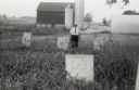
| Date: | 1958 |
|---|---|
| Description: | Local historian William F. Wolf visiting the Native American cemetery. In the background is a barn and a silo and other farm buildings. |
| Date: | 1961 |
|---|---|
| Description: | Vista over farmland from a small country cemetery. |

| Date: | 1928 |
|---|---|
| Description: | View down valley towards the back of the Lutheran Church and cemetery. Houses and barns are in the valley below, and more hills are in the far background. ... |

| Date: | 12 22 1906 |
|---|---|
| Description: | Text on front reads: "German Luth. Church near Whitehall, Wis." The church building on the right is surrounded by a farm, trees, fields and fences. |
If you didn't find the material you searched for, our Library Reference Staff can help.
Call our reference desk at 608-264-6535 or email us at:

