 Filter: Categories of Wisconsin Historical Images
Filter: Subject of Cemeteries
Filter: Subject of dwellings
Filter: Subject of roads
Filter: Categories of Wisconsin Historical Images
Filter: Subject of Cemeteries
Filter: Subject of dwellings
Filter: Subject of roads

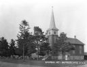
| Date: | 05 10 1928 |
|---|---|
| Description: | The Lutheran Church and buildings, seen from Lutheran Church Hill. |
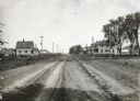
| Date: | 05 30 1916 |
|---|---|
| Description: | View down center of rural dirt road with houses along both sides in Black Hawk County. A man and horse are in a field on the left, near a sign that says: "... |
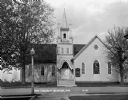
| Date: | 1931 |
|---|---|
| Description: | Exterior view from across street of the church. It has a bell steeple, stained glass windows, double french doors with an archway, and a wall gable facade.... |
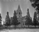
| Date: | 1922 |
|---|---|
| Description: | Exterior view from road of church. The church building features arched doors and windows, stained glass, and a bell steeple. There is a cemetery behind the... |
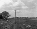
| Date: | |
|---|---|
| Description: | View along fence line of a rural area. There is a road on the left and farmland on the right. A person is traveling down the road, visible as a blur. In th... |

| Date: | 1925 |
|---|---|
| Description: | Elevated view of Coon Valley from a hilltop. Trees are on either side of the frame. In the city, there is a cemetery, church, and field of crops. |

| Date: | 1925 |
|---|---|
| Description: | View of a church, field, and cemetery from a hilltop. A car drives down the road in the lower-right corner. |

| Date: | |
|---|---|
| Description: | View from hill over church and cemetery towards fields and town in a valley. |
| Date: | 1922 |
|---|---|
| Description: | Exterior of the Methodist Church and the Denzer Cemetery. |

| Date: | 1868 |
|---|---|
| Description: | A detailed, cloth mounted map of Grant County that shows the townships, towns, roads, completed and under construction railroads, cemeteries, mills, lead m... |

| Date: | 1870 |
|---|---|
| Description: | A map of Iowa County, Wisconsin mounted on cloth that shows the villages of Avoca, Mifflin, Linden, Arena, Helena Station, Highland, Dodgeville, as well as... |
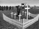
| Date: | 05 26 1997 |
|---|---|
| Description: | "Theresa American Legion Post 270 veterans visited seven cemeteries as they paid homage to departed comrades. Gary Erdman, Sargent-at-arms, stood at attent... |

| Date: | 1928 |
|---|---|
| Description: | View down valley towards the back of the Lutheran Church and cemetery. Houses and barns are in the valley below, and more hills are in the far background. ... |

| Date: | 06 12 1929 |
|---|---|
| Description: | This manuscript blueprint shows buildings with the names of their owners, tabernacle, location "where Strang found plates" and "house where Strang died," a... |

| Date: | 1887 |
|---|---|
| Description: | A plat map of Waterford. Township 4, North Range 19, East of 4th Principal Meridian. References at bottom include school houses, houses, churches and cemet... |
If you didn't find the material you searched for, our Library Reference Staff can help.
Call our reference desk at 608-264-6535 or email us at: