 Filter: Categories of Wisconsin Historical Images
Filter: Subject of Cemeteries
Filter: Subject of church buildings
Filter: Categories of Wisconsin Historical Images
Filter: Subject of Cemeteries
Filter: Subject of church buildings
| Date: | |
|---|---|
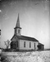
| Description: | Exterior portrait of a church with a steeple and a few grave markers surrounded by a snow-covered ground. Identified as the St. Malachi Church in Trout Run... |

| Date: | 1976 |
|---|---|
| Description: | This map includes an index of streets, government and historic buildings, hospitals, schools, places of recreation, churches, cemeteries, and other miscell... |
| Date: | |
|---|---|
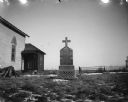
| Description: | View towards a tombstone in the side yard of a church. There are patches of snow on the ground, and a fence and another tombstone in the background. Patche... |

| Date: | 1883 |
|---|---|
| Description: | This map shows ward boundaries, names of additions, streets, bridges, mills, schools, religious buildings, businesses, hotels, railroads, factories, brewer... |

| Date: | 1934 |
|---|---|
| Description: | This map is attached to a cover. Streets, points of interest, the Milwaukee River, and Lake Michigan are labeled. The bottom margin of the map includes a s... |

| Date: | 1890 |
|---|---|
| Description: | This map shows lot and block numbers and dimensions, landownership, city wards, buildings, streets, railroads, parks, cemeteries, churches, schools, and in... |

| Date: | 1891 |
|---|---|
| Description: | This hand-colored map shows platted additions and subdivisions, ward boundaries, schools, churches, railroads, cemeteries, parks, businesses, factories, an... |

| Date: | 1965 |
|---|---|
| Description: | This map shows streets, churches, schools, wards, railroads, parks and fields, cemeteries, Historical Museum, Yacht Basin & Marina, and Marinette General H... |
| Date: | 1900 |
|---|---|
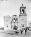
| Description: | Man posing on a horse-drawn mower in front of the ruins of a building surrounded by a fence. The building is probably a church as there are wreaths on grav... |

| Date: | 1900 |
|---|---|
| Description: | Rear view of a man on a horse-drawn mower. In the background are the ruins of a large building, probably a church. |

| Date: | 1860 |
|---|---|
| Description: | This map shows roads, railroads, rivers, townships, school houses, churches, cemeteries, and land ownership by name. Relief is shown by hachures. The map i... |
| Date: | 1874 |
|---|---|
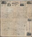
| Description: | This map shows townships and sections, land ownership and acreages, churches, schools, cemeteries, roads, railroads, and projected railroads. The map inclu... |

| Date: | 1912 |
|---|---|
| Description: | This blueprint manuscript map shows landownership, mills, railroad, churches, public buildings, the old cemetery, and the Chippewa River and Reservoir. The... |

| Date: | 1857 |
|---|---|
| Description: | This map shows lot and block numbers, buildings, some land ownership, wards, waterways, streets, railroads, brick yards, and cemeteries. It includes an ind... |

| Date: | 1905 |
|---|---|
| Description: | This photocopied map shows landownership, roads, railroads, rural mail routes, churches, school houses, cemeteries, and townships. The map includes adverti... |

| Date: | 1902 |
|---|---|
| Description: | This map shows townships, land parcels, schools, rivers, lakes, creameries, churches, cemeteries, roads, post offices, town halls, saw mills, roads and sto... |

| Date: | 06 23 2012 |
|---|---|
| Description: | Elevated view of a church with arched windows and a cemetery at the side of the building. |
| Date: | |
|---|---|
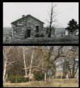
| Description: | A vintage view of the Laxey Church, paired with a modern view of the Laxey cemetery in the same location. |

| Date: | 1900 |
|---|---|
| Description: | This set of maps contains four sheets: "Landownership in the Vicinity of Military Reserve and Fort Howard," "Houses Along the River Road to Green Bay," "Ow... |
| Date: | |
|---|---|
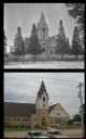
| Description: | A vintage view and a modern view of a church, presented as a pair. |
If you didn't find the material you searched for, our Library Reference Staff can help.
Call our reference desk at 608-264-6535 or email us at: