 Filter: Categories of Wisconsin Historical Images
Filter: Subject of Cemeteries
Filter: Subject of buildings
Filter: Categories of Wisconsin Historical Images
Filter: Subject of Cemeteries
Filter: Subject of buildings
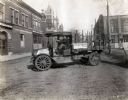
| Date: | 1919 |
|---|---|
| Description: | International model "F" "31" truck operated by Striplins Transfer of Litchfield. A male driver is in the truck which is parked on a city street between a ... |

| Date: | |
|---|---|
| Description: | A view of a cemetery with wooden crosses and bedsteads used as fences. |
| Date: | 1864 |
|---|---|
| Description: | "Andersonville Prison, Camp Sumter, Ga., as it appeared August 1st 1864 when it contained 35,000 prisoners of war." |
| Date: | |
|---|---|
| Description: | View of a Moravian Cemetery, used as a burial site from 1742 - 1910, selected and consecrated by Count von Zinzendorf. The cemetery features flat graveston... |

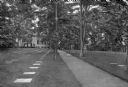
| Date: | 1870 |
|---|---|
| Description: | View toward the tombstones and a building at Hillside Cemetery and Park. In the foreground is a pond surrounded by vegetation. |

| Date: | 1868 |
|---|---|
| Description: | A detailed, cloth mounted map of Grant County that shows the townships, towns, roads, completed and under construction railroads, cemeteries, mills, lead m... |

| Date: | 1858 |
|---|---|
| Description: | This 1858 map of Racine County, Wisconsin, shows land ownership and acreages, the township and range grid, towns, cities and villages, roads, railroads, sc... |

| Date: | 1876 |
|---|---|
| Description: | This 1876 map of Saint Croix County, Wisconsin, shows the township and range grid, sections, towns, cities and villages, land ownership and acreages, wagon... |

| Date: | 1877 |
|---|---|
| Description: | This 1877 map of Sauk County, Wisconsin, shows the township and range grid, sections, towns, cities and villages, land ownership and acreages, wagon roads,... |

| Date: | 1862 |
|---|---|
| Description: | This map shows townships and sections, landownership and acreages, roads, railroads, cemeteries, churches, schools, mills, and stone quarries. "Engraved, p... |

| Date: | 1862 |
|---|---|
| Description: | This 1862 map of Winnebago County, Wisconsin, shows the township and range grid, towns, sections, cities and villages, railroads, roads, property owners an... |
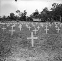
| Date: | 09 10 1943 |
|---|---|
| Description: | Crosses in the cemetery at Buna. Buildings and tents are in the background among trees. The American Forces lost 798 soldiers, and the Australians lost 2,7... |
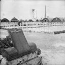
| Date: | 02 25 1945 |
|---|---|
| Description: | Memorial plaque and white crosses at a Marine cemetery on Tarawa Atoll in the South Pacific. Text on the plaque reads, "Semper Fidelis. At this site memori... |

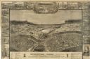
| Date: | 1857 |
|---|---|
| Description: | This map shows land ownership by name, local streets, wards, buildings, parks, a cemetery, and part of Lake Michigan. Depths are shown by soundings and nor... |

| Date: | 1893 |
|---|---|
| Description: | This map shows city wards, block numbers, parks, cemeteries, roads, railroads, selected buildings, and Lake Michigan. Also included are indexes to streets,... |

| Date: | 1900 |
|---|---|
| Description: | This map shows city wards, block numbers, parks, cemeteries, roads, railroads, Lake Michigan, and selected buildings. Also included are indexes "Milwaukee ... |

| Date: | 1901 |
|---|---|
| Description: | This map shows city wards, block numbers, parks, cemeteries, roads, railroads, Lake Michigan, and selected buildings. Also included are indexes "Milwaukee ... |

| Date: | 1920 |
|---|---|
| Description: | This map shows wards, streets, railroads, parks, cemeteries, select buildings, and Lake Michigan. Also included is a street index. Cemeteries and parks are... |

| Date: | 1860 |
|---|---|
| Description: | This map shows roads, railroads, rivers, townships, school houses, churches, cemeteries, and land ownership by name. Relief is shown by hachures. The map i... |

| Date: | 1877 |
|---|---|
| Description: | This map is a photstat copy of the original and shows landownership, townships and sections, wagon roads, railroads, school houses, churches, cemeteries, m... |
If you didn't find the material you searched for, our Library Reference Staff can help.
Call our reference desk at 608-264-6535 or email us at: