 Filter: Categories of Wisconsin Historical Images
Filter: Subject of Cemeteries
Filter: Community of Milwaukee
Filter: Year of 1800-1899
Filter: Categories of Wisconsin Historical Images
Filter: Subject of Cemeteries
Filter: Community of Milwaukee
Filter: Year of 1800-1899
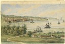
| Date: | 1858 |
|---|---|
| Description: | View from the second story of the Salesianum, the residence of Dr. Salzmann. The view includes Lake Michigan, the Milwaukee shoreline, and some of the nume... |

| Date: | 1840 |
|---|---|
| Description: | Pen-and-ink on paper. Map shows 1840’s homes with owner names, a Native American cemetery, and other points of interest. Relief shown by hachures. Oriented... |

| Date: | 1892 |
|---|---|
| Description: | This map shows water pipes, hydrants, stop cocks, check valves, fire cysterns, and manholes. Also shown are block numbers, streets, railroads, parks, cemet... |

| Date: | 1892 |
|---|---|
| Description: | This map shows schools, engine houses, railroads, street railways, wards, parks, cemeteries, block numbers, a street index, explanations, and general refer... |

| Date: | 1893 |
|---|---|
| Description: | This map shows city wards, block numbers, parks, cemeteries, roads, railroads, selected buildings, and Lake Michigan. Also included are indexes to streets,... |

| Date: | 1897 |
|---|---|
| Description: | This map shows city wards, block numbers, parks, cemeteries, roads, railroads, Lake Michigan, and selected buildings. Also included are indexes to streets,... |

| Date: | 1898 |
|---|---|
| Description: | This map shows city wards, block numbers, parks, cemeteries, roads, railroads, Lake Michigan, and selected buildings. Also included are indexes "Milwaukee ... |

| Date: | 1894 |
|---|---|
| Description: | This map shows sewers, intercepting sewers, manholes, block numbers, streets, railroads, parks, cemeteries, and Lake Michigan. The right margin reads: "Tot... |

| Date: | 1896 |
|---|---|
| Description: | This map shows streets, wards, railroads, parks, cemeteries, and Lake Michigan. Also included are explanations and an index of points of interest. |

| Date: | 1897 |
|---|---|
| Description: | Two maps that show cemeteries, schools, engine houses, railroads, street railways, wards, roads, parks, block numbers, and Lake Michigan. One map has wards... |

| Date: | 1879 |
|---|---|
| Description: | This map shows asylums, cemeteries, hospitals, parks, streets, and wards. Relief is shown by contours. Also included are manuscript annotations in pencil. ... |

| Date: | 1890 |
|---|---|
| Description: | This map shows city wards, block numbers, parks, cemeteries, roads, railroads, and selected buildings. The map includes indexes to streets, public building... |

| Date: | 1888 |
|---|---|
| Description: | This map shows city wards, block numbers, parks, cemeteries, roads, railroads, and selected buildings. The map includes indexes to streets, public building... |
If you didn't find the material you searched for, our Library Reference Staff can help.
Call our reference desk at 608-264-6535 or email us at: