 Filter: Categories of Wisconsin Historical Images
Filter: Subject of Capitols
Filter: Year of 1900-1999
Filter: Year of 1900-1909
Filter: Categories of Wisconsin Historical Images
Filter: Subject of Capitols
Filter: Year of 1900-1999
Filter: Year of 1900-1909
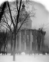
| Date: | 02 27 1904 |
|---|---|
| Description: | The east wing of the third Wisconsin State Capitol is surrounded by onlookers during the disastrous fire that caused severe damage. The conflagration began... |
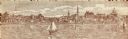
| Date: | 1900 |
|---|---|
| Description: | A view of the city of Madison circa 1900 that was used as a letterhead. |

| Date: | 1904 |
|---|---|
| Description: | This map shows numbered wards and plots, labelled streets, and parks in green. |

| Date: | 1907 |
|---|---|
| Description: | Shows public buildings, hotels, fraternity houses, and private houses. Index of fraternities and sororities, residences, public buildings, hotels, places o... |

| Date: | 1908 |
|---|---|
| Description: | Shows pipes of various sizes, hydrants, valves, and wells. "1907" -- Lower margin. Lake Wingra, Lake Monona, and Lake Mendota are labelled. |

| Date: | 1909 |
|---|---|
| Description: | Streets, Lake Wingra, Lake Mendota, and Lake Monona are all labelled. Map reads: "The present park system of Madison comprises 150 acres of improved parks,... |

| Date: | 1906 |
|---|---|
| Description: | This map shows shows streets, subdivisions, railroads, places of interest including the State Capitol, the University of Wisconsin, Camp Randall, Henry Vil... |

| Date: | 1908 |
|---|---|
| Description: | A Sanborn map featuring the Capitol Square and surrounding business district. |
If you didn't find the material you searched for, our Library Reference Staff can help.
Call our reference desk at 608-264-6535 or email us at:
