Filter: Categories of Wisconsin Historical Images
Filter: Subject of Capitols
Filter: Year of 1800-1899
Filter: Subject of transportation
Filter: Categories of Wisconsin Historical Images
Filter: Subject of Capitols
Filter: Year of 1800-1899
Filter: Subject of transportation
| Date: | 1876 |
|---|---|
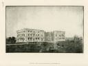
| Description: | View from the Wisconsin State Capitol down State Street to Main Hall (later Bascom Hall), the University of Wisconsin and beyond. Entitled "Views of the c... |
| Date: | 1875 |
|---|---|
| Description: | Lake Mendota shore looking west with A.L. Dahl's photographer's wagon on shore and the Wisconsin State Capitol visible in the background. |
| Date: | 1876 |
|---|---|
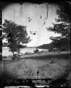
| Description: | Issued as a stereograph on green mount entitled "The Artist." Two men stand by a wagon on which is written "A.L. Dahl Landscape Photographer." The flag on... |
| Date: | 1878 |
|---|---|
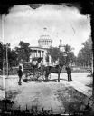
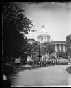
| Description: | Group in front of the Centennial Fountain on Capitol Square. View of the capitol from Monona Avenue. The fountain is a replica of the Centennial Fountain... |

| Date: | 1876 |
|---|---|
| Description: | "View of the Capitol, with all the Flags" one of four "Different Views of Parades in the Streets" identified in Dahl's 1877 "Catalogue of Stereoscopic View... |
| Date: | 1870 |
|---|---|
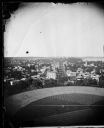
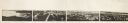
| Description: | Panoramic view of Madison, taken from the roof of South Hall. This reduced copy was made from original negatives by E.C. Nielson. Labels for both Lake Mend... |

| Date: | 1835 |
|---|---|
| Description: | Map reads: "Map of the United States of America with its Territories and Districts - Including also a part of Upper and Lower Canada and Mexico". The map i... |
| Date: | 1864 |
|---|---|
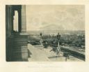
| Description: | View down capitol building steps, where cannons sit on a landing, and statues decorate two lampposts. The city spreads out far below. Plate 03 |

| Date: | 1853 |
|---|---|
| Description: | Wisconsin counties by color and shows railroads, common roads, canals, the state capital, county towns, townships, villages, and post offices, |

| Date: | 1854 |
|---|---|
| Description: | Map of the whole state Wisconsin includes an inset of the vicinity of Milwaukee, which shows the boundaries for Lisbon, Menomonee, Pewaukee, Brookfield, Wa... |
| Date: | 1814 |
|---|---|
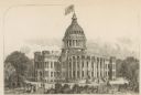
| Description: | Exterior view of the U.S. Capitol building after the fire in August. The Federal building was burned by British forces during the War of 1812. In the foreg... |
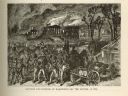
| Date: | 1814 |
|---|---|
| Description: | Etching depicting the burning of Washington, D.C. by the British during the War of 1812. In the foreground are a number of soldiers moving toward the Capit... |

| Date: | 1835 |
|---|---|
| Description: | Plat for a proposed Sinsinawa City (never built), in Grant County, Wis. When it became clear in the mid-1830s that Wisconsin Territory would be established... |

| Date: | 1887 |
|---|---|
| Description: | City water works system map. Pencil annotation on the top right reads: "Period represented is after 1887 and before Aug. 1891". The middle of the map has a... |

| Date: | 1873 |
|---|---|
| Description: | This map shows lots and blocks, additions and subdivisions, and large-scale landownership. The map is oriented with north to the upper right. The map is fr... |

| Date: | 1887 |
|---|---|
| Description: | Shows pipes of various sizes, hydrants with hydrant pressure, valves, wells, and projected lines. |

| Date: | 1888 |
|---|---|
| Description: | Shows ward divisions and street railways, as well as University of Wisconsin buildings, churches, and schools. Cataloged from copy with right and left edge... |

| Date: | 1892 |
|---|---|
| Description: | Shows pipes of various sizes, hydrants with hydrant pressure, valves, wells, and projected lines. Differs from earlier versions by inclusion of Wingra Park... |

| Date: | 1851 |
|---|---|
| Description: | This map shows plats with lots and block numbers of Madison. The far left corner features "University Ground" and some streets are labeled. Lake Monona is ... |
If you didn't find the material you searched for, our Library Reference Staff can help.
Call our reference desk at 608-264-6535 or email us at: