 Filter: Categories of Wisconsin Historical Images
Filter: Subject of Canoes and canoeing
Filter: Subject of mountains
Filter: Categories of Wisconsin Historical Images
Filter: Subject of Canoes and canoeing
Filter: Subject of mountains
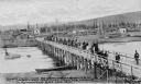
| Date: | 05 20 1905 |
|---|---|
| Description: | Elevated view of a group of miners on horseback crossing a bridge into Fairbanks, Alaska, May 20th, 1905. Houses are on the other side of the river. Captio... |
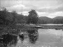
| Date: | |
|---|---|
| Description: | Girls canoe near a dock at Camp Lenoloc as additional girls watch from the shoreline. Trees and other foliage line the water and mountains are in the backg... |

| Date: | 1930 |
|---|---|
| Description: | Pictorial map of Glacier National Park, Montana and Waterton Lakes National Park, Alberta. Illustrated by Joe Scheurle, it depicts white people, American ... |

| Date: | 1930 |
|---|---|
| Description: | The back of the pictorial map titled Recreational Map of Glacier National Park, Montana: Waterton Lakes National Park, Alberta. 14 panels of text and photo... |

| Date: | 1783 |
|---|---|
| Description: | This map is hand-colored and shows the boundaries of British, Spanish, and the newly recognized American claims, as well as the fishing rights granted to F... |

| Date: | 1718 |
|---|---|
| Description: | Map of the Southern portion of North America from New Mexico to Florida and south from Lake Erie. It shows borders, cities, settlements, Native American la... |

| Date: | 1930 |
|---|---|
| Description: | An original lithograph depicting a scene in the Colorado Rockies. Text at top reads: "Colorado Rockies, Black Hills and Utah, Land of Scenic Marvels." Text... |
If you didn't find the material you searched for, our Library Reference Staff can help.
Call our reference desk at 608-264-6535 or email us at: